
Gan International Airport
From Wikipedia, the free encyclopedia
Gan International Airport
ގަން ބައިނަލްއަޤްވާމީ ވައިގެބަނދަރު 
IATA: GAN – ICAO: VRMG Summary Airport type Public Owner/Operator Addu International Airport Pvt Ltd. Serves Addu City, Maldives Location Gan, Addu Atoll Elevation AMSL 6 ft / 2 m Coordinates 00°41′36″S073°09′20″ECoordinates: 00°41′36″S 073°09′20″E Website Maps 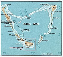
Map of Addu Atoll showing Gan and airfield

 GAN
Location in Maldives
GAN
Location in Maldives Runways Direction Length Surface m ft 10/28 2,650 8,694 Concrete Source: DAFIF[1][2]
Gan International Airport (IATA: GAN, ICAO: VRMG) is located on the island of Gan in Addu Atoll (previously known as Seenu Atoll) in the Maldives.[1]
First built by the Royal Navy, and transferred to the Royal Air Force as RAF Gan, it was a military airbase used during World War II and until 1976. The British handed it over to the government and it was used as a domestic airport. Recently the airport has been upgraded to international standards in preparation for international flights with the opening of tourist resorts in the area.
Gan International Airport (GIA) serves as a key tourism gateway to the Republic of Maldives and its luxury beach resorts and dive sites. GIA is situated at the southern tip of the country, and allows international and domestic aircraft movements year-round.
The airport was run by the Government of Maldives (GoM) with a human resource base consisting of civil servants along with technical assistance from Maldives Airports Company Limited (MACL) until January 2010. In June 2009 a public enterprise by the name of Gan Airport Company Limited (GACL) was established by H.E. the President as part of GoM's privatization policy. GACL took over management of GIA in January 2010.
A transitional stage followed with administrative restructuring which also involved formal transfer of existing civil servants into the company's new organizational structure.
In order to promote tourism and other economic activity in the south a new venture was formed early in 2012 to further develop and expand GIA. A joint venture was formed between GACL, MACL and State Trading Organization plc (STO). The new venture is Addu International Airport pvt ltd (AIA).
Gan International Airport is now owned and managed by Addu International Airport pvt ltd.
From Wikipedia, the free encyclopedia
| Gan International Airport ގަން ބައިނަލްއަޤްވާމީ ވައިގެބަނދަރު | |||
|---|---|---|---|
 | |||
| IATA: GAN – ICAO: VRMG | |||
| Summary | |||
| Airport type | Public | ||
| Owner/Operator | Addu International Airport Pvt Ltd. | ||
| Serves | Addu City, Maldives | ||
| Location | Gan, Addu Atoll | ||
| Elevation AMSL | 6 ft / 2 m | ||
| Coordinates | 00°41′36″S073°09′20″ECoordinates: 00°41′36″S 073°09′20″E | ||
| Website | |||
| Maps | |||
 Map of Addu Atoll showing Gan and airfield | |||

GAN
| |||
| Runways | |||
| Direction | Length | Surface | |
| m | ft | ||
| 10/28 | 2,650 | 8,694 | Concrete |
| Source: DAFIF[1][2] | |||
Gan International Airport (IATA: GAN, ICAO: VRMG) is located on the island of Gan in Addu Atoll (previously known as Seenu Atoll) in the Maldives.[1]
First built by the Royal Navy, and transferred to the Royal Air Force as RAF Gan, it was a military airbase used during World War II and until 1976. The British handed it over to the government and it was used as a domestic airport. Recently the airport has been upgraded to international standards in preparation for international flights with the opening of tourist resorts in the area.
Gan International Airport (GIA) serves as a key tourism gateway to the Republic of Maldives and its luxury beach resorts and dive sites. GIA is situated at the southern tip of the country, and allows international and domestic aircraft movements year-round.
The airport was run by the Government of Maldives (GoM) with a human resource base consisting of civil servants along with technical assistance from Maldives Airports Company Limited (MACL) until January 2010. In June 2009 a public enterprise by the name of Gan Airport Company Limited (GACL) was established by H.E. the President as part of GoM's privatization policy. GACL took over management of GIA in January 2010.
A transitional stage followed with administrative restructuring which also involved formal transfer of existing civil servants into the company's new organizational structure.
In order to promote tourism and other economic activity in the south a new venture was formed early in 2012 to further develop and expand GIA. A joint venture was formed between GACL, MACL and State Trading Organization plc (STO). The new venture is Addu International Airport pvt ltd (AIA).
Gan International Airport is now owned and managed by Addu International Airport pvt ltd.
Contents
Facilities[edit]
The Executive Terminal built for the SAARC summit in 2011 was taken over by Shangri-La’s Villingili Resort and Spa for the exclusive arrival and departure of Shangri-La’s guests at Gan. The first private executive terminal in the Maldives.
Commenting at the official launch on January 31, 2013 Rene D. Egle, the resort’s general manager, said, “Providing our guests with a luxurious experience and a truly personalised welcome from the moment they land is for me a great achievement. I am very thankful to the local authorities and the Gan International Airport team for their excellent cooperation since initial discussions on this project. Today is a great day for our resort and Addu Atoll and we are ready to welcome our international clientele from all over the world, either via Male or directly to Gan by private jet.”
The airport resides at an elevation of 6 feet (2 m) above mean sea level. It has one runway designated 10/28 with a concrete surface measuring 2,650 by 45 metres (8,694 ft × 148 ft).[1]
Airlines and destinations[edit]
Airlines offering scheduled passenger service:
Airlines Destinations Flyme Malé Maldivian Malé, Kaadedhdhoo, Kadhdhoo, Kooddoo Airport, Fuvahmulah
Seasonal: Colombo Mega Maldives Seasonal Charter: Chongqing, Hong Kong, Malé, Seoul-Incheon
Airlines offering scheduled passenger service:
| Airlines | Destinations |
|---|---|
| Flyme | Malé |
| Maldivian | Malé, Kaadedhdhoo, Kadhdhoo, Kooddoo Airport, Fuvahmulah Seasonal: Colombo |
| Mega Maldives | Seasonal Charter: Chongqing, Hong Kong, Malé, Seoul-Incheon |
References[edit]
- ^ a b c Airport information for VRMG from DAFIF (effective October 2006)
- ^ Airport information for GAN at Great Circle Mapper. Source: DAFIF (effective Oct. 2006).
- ^ a b c Airport information for VRMG from DAFIF (effective October 2006)
- ^ Airport information for GAN at Great Circle Mapper. Source: DAFIF (effective Oct. 2006).
External links[edit]
Malaysian Airlines MH370: live
Maldives 'witnesses' report seeing 'low flying jet' on morning that MH370 disappeared - follow latest updates on missing Malaysia Airlines plane
This page will automatically update every 90 secondsOnOff
• Maldives 'sighting' of low flying plane
• Five Indian Ocean runways found on Captain's simulator
• Chinese relatives go on hunger strike for information
• Australia admits search is like looking for 'needle in haystack'
• 2.24 million square nautical mile search area
• Deep sea search equipment being used
• China finds no terror links to nationals on flight
• Co-pilot spoke final words - "All right, good night"
• Could Malaysia Airlines flight MH370 have landed undetected?
• In pictures: The hunt for MH370
Latest
16.53 David Cameron has been providing more detail of his conversation with his Malaysian counterpart.
I wanted to discuss the help we have already been able to give with the UK-based satellite company that has been talking to the Malaysian authorities and to offer any other help that we could possibly give and to see if he had any particular requests or ideas for things that Britain could do.
We are good friends with the Malaysians, it's a very close relationship between our countries, we feel for them at this time and we want to help in any way we can.
16.53 David Cameron has been providing more detail of his conversation with his Malaysian counterpart.
I wanted to discuss the help we have already been able to give with the UK-based satellite company that has been talking to the Malaysian authorities and to offer any other help that we could possibly give and to see if he had any particular requests or ideas for things that Britain could do.
 I wanted to discuss the help we have already been able to give with the UK-based satellite company that has been talking to the Malaysian authorities and to offer any other help that we could possibly give and to see if he had any particular requests or ideas for things that Britain could do.
We are good friends with the Malaysians, it's a very close relationship between our countries, we feel for them at this time and we want to help in any way we can.
Related Articles
16.35 Now this is essential reading.
Chris Goodfellow, a pilot with 20 years experience, has the following theory:
What I think happened is the flight crew was overcome by smoke and the plane continued on the heading, probably on George (autopilot), until it ran out of fuel or the fire destroyed the control surfaces and it crashed. You will find it along that route–looking elsewhere is pointless.
His suggestion is that there was a fire onboard, and that the pilot tried to double back to the nearest safe runway to land.
He adds maps and past case studies to back up his theory.
Get on Google Earth and type in Pulau Langkawi and then look at it in relation to the radar track heading. Two plus two equals four. For me, that is the simple explanation why it turned and headed in that direction. Smart pilot. He just didn’t have the time.
16.15 Another brilliant response:
Here's more detail on the CNN show:
After CNN anchor Don Lemon "went there" and threw out the possibility of a "supernatural" event causing the disappearance of Malaysia Airlines Flight 370, he spent Monday's show inviting Twitter users to send in all their crazy questions and theories about the missing jet for debate.
Among the possibilities Lemon's panel of experts evaluated: that the plane was "stolen" to use in a later terror attack (deemed possible), that the plane was actually in North Korea (not possible) and that pilots could depressurize the plane to cause passengers to pass out (possible).
One Twitter user even asked why CNN anchor Richard Quest filmed a recent story with Malaysia Airlines. Quest said he did fly with the co-pilot of the missing jet - but ruling out a CNN conspiracy, he said the encounter was "pure coincidence and luck."
Filipino students work on a painting of Malaysia Airlines Flight MH370 at the Benigno Ninoy Aquino High School grounds in Makati City, Philippines.
16.03 David Kaminski Morrow, air transport editor atFlight Global, has shared his thoughts on the Maldives "sighting" (see 13.52) with The Telegraph.
He said
- The plane, a Boeing 777-200, was capable of travelling as far as the Maldives
- Male is the main airport but the sighting appears to have come from an atoll a long way south
- Commercial aircraft-tracking software, while not always reliable, doesn’t seem to show any other nearby traffic with which a sighting might have been confused
Mr Kaminski Morrow said:
It is all hugely, hugely tentative - and I wouldn't want to vouch for the newspaper which is the source of this information.
But theoretically it could be possible.
The vital detail is the fuel; Malaysia Airlines has not said how much fuel was on board, other than to say "enough for the trip to Beijing".
Therefore we can't tell if that was enough to loop around and make it back to the Maldives.
15.38 We're working on bringing you more details of the claim from the Maldives.
But David Kaminski Morrow, air transport editor at Flight Global, makes this point:
15.23 One of our readers, David Barchard, has got in touch to share his thoughts on the possible sighting of the plane in the Maldives.
He writes:
If the Maldive lead turns out to be a strong one, then the next question is: could the plane conceivably have flown to Somalia? Or somewhere in the southern Arabian peninsula or Iran? Somalia seems a much more likely destination for a hijacker with its known al-Qaeda connections.
From the maps that have been published, it looks as if it would be beyond its range, but a hijacking pilot might have made provision to cover the distance. How much extra fuel does the plane use up by flying low?
15.11 And returning to the most dramatic new line of this afternoon - the report that people in the Maldives saw a low-flying plane...
15.08 Our Washington correspondent, Raf Sanchez, has been reading the coverage of the disappeared plane in the American press for us.
He says that The New York Times gives another reason to focus on the pilots: apparently the turning off of the flight path from Beijing was done through entering new coordinates into the Flight Management System, rather than just turning the plane manually. The manoeuvre is complicated and can only be done by someone with serious aviation knowledge.
He writes:
There are three ways to turn a major aircraft like the Boeing 777:
1. Turn it manually using the yoke, or steering wheel. This is the most basic method and the one most likely to be used by a hijacker with only basic aviation knowledge
2. If the autopilot is engaged, you can adjust the aircraft's heading i.e. tell the plane to fly in a different direction. This is more complicated than steering the aircraft yourself but plausible that a hijacker could manage it.
3. Enter a new set of coordinates into the aircraft's Flight Management System (FMS). This is seriously complicated and involves instructing the aircraft to construct a new flight plan using different turning points. Only someone with serious knowledge could pull this off.
The New York Times reports today that MH370's turn off the flight path towards Beijing was done using the third, and most complicated, method.
Why is that significant? Because it gives one more reason to focus on the pilots as the possible perpetrators of MH370's disappearance.
As The New York Times put it:
"Whoever changed the plane’s course would have had to be familiar with Boeing aircraft, though not necessarily the 777 — the type of plane that disappeared. American officials and aviation experts said it was far-fetched to believe that a passenger could have reprogrammed the Flight Management System."
15.07 Britain has not yet been asked to provide any specific piece of equipment or military unit.
General Sir Nick Houghton, chief of defence staff, confirmed that he spoke yesterday to his Malaysian counterpart and said that the UK military was ready to consider any requests for assistance, said the Ministry of Defence.
14.50 Thailand has claimed that it detected an unidentified plane minutes after the last contact fromMH370 but - bizarrely - didn't share the information with Malaysia earlier because it wasn't specifically asked for it.
A twisting flight path described today by Thai air force spokesman Air Vice Marshal Montol Suchookorn took the plane to the Strait of Malacca, which is where Malaysian radar tracked Flight 370 early on March 8. But Montol said the Thai military doesn't know whether it detected the same plane.
Thailand's failure to quickly share possible information regarding the fate of the plane, and the 239 people aboard it, may not substantially change what Malaysian officials know, but it raises questions about the degree to which some countries are sharing their defense information.
14.20 This spoof report, in The New Yorker, is great.
CNN apologised to its viewers today for briefly airing a story on Sunday that had nothing to do with the missing Malaysia Airlines flight.
The story, which caused thousands of viewers to contact the network in anger, had something to do with Crimea, Ukraine, and Russia.
In the official apology, CNN chief Jeff Zucker wrote, “On Sunday, we briefly cut away from our nonstop coverage of Flight 370 to talk about something else. We’re not going to sugarcoat it: we messed up. CNN regrets the error and promises our viewers that it won’t happen again.”
14.08 David Cameron has telephoned Najib Razak, the Malaysian prime minister, to offer his support.
Mr Cameron's spokesman said:
It was very much inviting any specific requests from the Malaysians. Prime Minister Najib said he would think about that and let us know if they have any specific requests.
Mr Cameron wanted to "make clear his thoughts are particularly with all the relatives of those who were on board the missing flight" and to "offer any support which the Malaysian authorities might find helpful", said the spokesman.
Prime Minister Najib thanked him for that and they agreed to stay in touch on this issue.
13.52 Reports from a Maldives news organisation that islanders saw a "low flying jumbo jet". The Haveeru news website reports witnesses saw a plane flying low at around 6.15am on March 8. It was apparently flying north to south-east. A witness told the news organisation
I've never seen a jet flying so low over our island before. We've seen seaplanes, but I'm sure that this was not one of those. I could even make out the doors on the plane clearly.
It's not just me either, several other residents have reported seeing the exact same thing. Some people got out of their houses to see what was causing the tremendous noise too.
12.46 Intriguing new line from The Malay Mail Online.
Police scouring Capt Shah's flight simulator - which he installed in his home - have found five Indian Ocean practice runways.
One is in the Maldives.
One is on Diego Garcia.
The other three are in India and Sri Lanka.
We are not discounting the possibility that the plane landed on a runway that might not be heavily monitored, in addition to the theories that the plane landed on sea, in the hills, or in an open space.
12.34 This video, produced by The Wall Street Journal, is a great summary of theories about the disappearance of the plane.
It was published on Saturday but is still worth a watch.
12.19 A political cartoonist from Malaysia, Zunar, has got in touch to send us one of his drawings.
He says:
This cartoon represents the perspective of Malaysians rather that the government, so we can look at different point of view.
Cartoon by Malaysian political cartoonist, Zunar
12.09 Much has been made over the past few days of Capt Zaharie Ahmad Shah's links to Anwar Ibrahim, the opposition leader, who was sent to prison on Saturday - hours before the plane disappeared.
It now emerges that Capt Shah was a distant relative of Ibrahim.
Some said that the pilot was a "fanatical" supporter of Ibrahim - yet others pointed out that there was nothing at all sinister about the dissident politician.
Capt Shah, 53, was an active member of Anwar's Parti Keadilan Rakyat (People's Justice Party), and some have suggested he might have sabotaged the flight as an act of political revenge.
And Anwar Ibrahim has spoken out about the swirling allegations. He told AFP news agency:
Is it a crime for anyone to be a member of Keadilan? To me it is an attempt to deflect the government's incompetence.
I of course did not take the news reports seriously but I am speaking out because I sympathise with the pilot and his family.
The mysterious disappearance of MH370 reflects not only an incompetent regime ruling the country but an irresponsible government.
11.58 We're working on bringing you an up-to-date list of all the theories - from the realistic to the really wild - about what has happened to the plane.
But in the meantime, here is more detail of one possible suggestion: that the plane was "cyber hijacked".
This was mentioned yesterday; essentially someone on the plane or on the ground could use a mobile phone or a USB stick to over-ride the plane's settings.
Ondrej Vlcek, chief operating officer at AVAST - an antivirus company - says:
The theory is extremely wild and unlikely. The entertainment systems on most airline carriers are relatively old and independent from the main computer systems of the aircraft such as position, temperature, etc. There is no feedback communication from the entertainment system to the main computer. It is basically only one way information for passengers.
11.55 The Telegraph's video desk has just received this footage from Beijing, where anxious relatives have been waiting for news for ten days.
11.46 Another interesting question is whether Malaysia has the necessary radars to track the plane.
The Wall St Journal has produced a detailed analysis of the country's detection capability.
In Southeast Asia, governments often favor prestige items, such as submarines and fighter jets, over less-glamorous but essential capabilities like radars.
Unlike Malaysia, Singapore and Thailand both invested in early-warning aircraft, though they would have had to be airborne to spot Flight 370.
While small aircraft could fly low enough to avoid radar, it would be almost impossible for a Boeing 777-200 to dodge an air-defense system operating effectively, according to Keith Hayward, head of research at the UK's Royal Aeronautical Society.
"You'd have to fly well below 100 meters, and the 777 is not designed to fly that low," Mr. Hayward said. "You would exceed the aircraft's stress levels."
Ground-based military radar typically has a range of up to 250 miles, its extent being limited by the Earth's curvature, Mr. Hayward said. That should have put Flight 370 within the range of Thai military radar, and possibly also Indonesian and Indian radar, as it flew west of Malaysia. However, all three of those countries have said they saw no sign of the missing plane.
11.32 ITV news are now reporting that a student from Hull University is among the missing passengers from flight MH 370.
Yue Wenchao, 26, had moved to the UK to study at the University of Hull Business School.
Hull University told ITV News that they were "deeply concerned" the student may be among the missing passengers but refused to confirm the reports.
We are deeply concerned to hear that Yue Wenchao, a student in the final stages of his MSc degree with Hull University Business School, may be among the passengers onboard the missing Malaysia Airlines’ flight," a statement said.
Although we are not able to confirm these reports at this time, our thoughts are with the friends and relatives of all those affected.
11.25 As discussed at this morning's press conference (see 09.58), some of the Chinese relatives awaiting news in Beijing are reported to have begun a hunger strike in order to obtain more information.
Speaking to reporters, a woman who had led the chanting held up a piece of paper with slogans written on it, and said the families were calling for a hunger strike.
"Respect life, return our relatives. Can everyone read it? Can everyone read it?" she asked.
"We're going on hunger strike. I'm representing," she said.
Read the full story here:
11.01 Michael Wolff has written an entertaining piece in today's Guardian entitled "The new anti-journalism; all data, no real facts, endless theories."
He writes:
Free conspiracies are for sale, with cautious restraint that propels the absence of truth. But you’re still obsessed, aren't you?
10.52 Hold the front page: Courtney Love thinks she has found the plane.
The singer, and widow of Nirvana frontman Kurt Cobain, posted an image on her Facebook page with the caption:
I’m no expert but up close this does look like a plane and an oil slick.
Almost 10,000 people "liked" her diagram...
10.42 Our correspondent in Kuala Lumpur, Jonathan Pearlman, has been listening to the press conferences over the past few days.
This is his assessment of today's event:
The most interesting development was that the head of Malaysia Airlines said neither the pilot nor the co-pilot have experience flying either of the two corridors in which the plane is believed to have ended up.
The acting minister for transport also revealed that the search area spans 2.24 million square miles.
Authorities still believe the plane was deliberately taken off course - but are not ruling out pilot error.
10.28 For another way of looking at the search area, Commander William Marks, spokesman for America's 7th Fleet - which is currently based in Manila, said:
If you superimpose a map of the United States from the northern part of the Indian Ocean to the southern part of Australia, it is as if we are looking for a few people somewhere between New York and California and we don't know where.
Crew members on board the RAAF AP3C Orion aircraft during the search operation
10.20 Australia, it was announced yesterday, is leading the search of the southern corridor.
But today they have admitted that their search across 230,000 square miles of Indian Ocean is akin to searching for "a needle in a haystack".
John Young, emergency response general manager for the Australian Maritime Safety Authority, said:
This search will be difficult. The sheer size of the search area poses a huge challenge - the search area is more than 600,0000 square kilometres.
A needle in a haystack remains a good analogy.
It will take at least a few weeks to search the area thoroughly.
10.17 So what did we learn from this morning's press conference?
- The pilots would not have been accustomed to flying over either the northern or southern corridors.
- Both corridors are divided into seven quadrants.
- The total search area is now 2.24 million sq nautical miles.
- The ACARS system was disabled some time between 1.07am and 1.37am.
10.10 A final question.
Was the plane's flight path programmed?
As far as we are concerned, it was programmed to fly to Beijing.
Once you are in the aircraft, anything is possible.
10.08 Hishammuddin Hussein, Malaysia's transport minister, is being asked about "international plots".
The reporter is obviously referring to the stories of "9/11 style" attacks.
I would not want the team to be distracted by other issues.
It is imperative that within the corridors all efforts are directed to locating the aircraft.
I believe if we can find the aircraft soon, Inshah Allah, then we will find the black box and answer these questions.
10.07 Malaysia Airlines representative confirms that the pilot would not have been familiar with the northern or southern corridor routes, because the company does not have any routes in that direction.
This is a map of the northern corridor.
A handout picture released by the Malaysian prime minister's office shows a map of the northern search corridor for the missing Malaysian Airlines flight MH370
10.04 Mr Hussein is being asked about the data which has been released - and what information they are witholding.
I have stated on the record that we have put aside our national security interests, to release sensitive radar data.
We have put the interests of the passengers and the plane above national security interests.
10.01 The team are being asked, by a France 24 reporter, about why it took them seven days to confirm the plane performed a U-turn.
The France 24 journalist then asked Hishammuddin Hussein, Malaysia's transport minister, whether he can confirm he is the cousin of Najib Razak, the prime minister, "and whether he is being protected."
He looks deeply unimpressed.
Protected from what?
They move on to the next question.
09.58 The team are being asked about the hunger strike which Chinese relatives are said to have begun, to press for more information.
They say they will "look into it".
09.56
09.51 Hishammuddin Hussein, Malaysia's transport minister, has been asked about internal political rivalries affecting the search.
He replies:
We have been very consistent. The government's position has always been - and remains - that this question is above politics.
It is the foreign press which has brought that up. If I am not mistaken, it was The Daily Mail and CNN who brought politics into this.
Malaysian acting Transport Minister Hishammuddin Hussein, second from right, speaks as Malaysian Foreign Minister Anifah Aman, right, Malaysia's Department of Civil Aviation director general Azharuddin Abdul Rahman, second left, and Malaysia Airlines Group Chief Executive Ahmad Jauhari Yahyain listen during a press conference at a hotel in Sepang, Malaysia
09.50 Malaysia's transport minister says that they have consulted the US about using their satellite data.
Earlier, the foreign affairs minister said that many countries were handing over their satellite information - but he wouldn't say which countries, or what data.
Of course, the question of who has what satellites, and where, is very sensitive.
09.49 The team are taking questions now from the many journalists gathered in the Sama Sama hotel.
They have been criticised over the past ten days for providing contradictory accounts.
Here's more detail on how Malaysia has handled this crisis:
09.41 Mr Aman has been in Europe this week, he says, and has been heartened by the sympathy and offers of help.
But he continues, in a pointed manner:
The main objective is to locate the aircraft. This search is bigger than politics.
Nobody should seek to make cheap points from this.
09.40 Now Malaysia's foreign minister, Anifah Aman, is speaking.
He says 14 diplomatic notes have been sent to the countries involved in the search.
09.38 Hishammuddin Hussein, Malaysia's transport minister, on the contradictory statements over the past week about the timing of the disabling of ACARS.
It is important to realise that the exact time the ACARS was switched off has no bearing on the location of the plane.
Our priority has always been to find the aircraft.
An Australian AP-3C Orion maritime patrol aircraft scans the surface of the sea during a search operation for the missing Malaysia Airlines Flight
09.37 He is now moving on to talk about ACARS (Aircraft Communications Addressing and Reporting System) and the timeframe.
This is crucial - and something that Malaysia has been criticised for muddling.
09.35 Mr Hussein says the search area is enormous - the southern corner is comprised of six quadrants measuring 400 nautical miles by 400 nautical miles.
The northern corridor is also 1600 sq nautical miles.
This means that the total search area is 2.24m square nautical miles.
This is an enormous search area, and something that Malaysia cannot search alone.
I am pleased that so many countries have come forward to help.
09.34 Hishammuddin Hussein, Malaysia's transport minister, has begun the press conference.
Yesterday I stated that the search has entered a new phase.
The search and rescue operations have taken on a new international dimension. The search is still coordinated by Malaysia, but has taken on a more international role.
Over the past 24 hours, we have been working hard with our colleagues to narrow the search corridors.
09.33 This map shows the southern corridor that is being searched.
A handout picture released by the Malaysian prime minister's office shows a map of the Southern search corridor for the missing Malaysian Airlines flight
09.25 We are expecting the daily press conference, from the Sama Sama hotel at Kuala Lumpur airport, to begin any moment.
09.21 A relative of a passenger onboard the missing Malaysia Airlines Flight MH370 checks his mobile phone as he waits for news about the missing plane:
Reuters
09.20 Jonathan Pearlman on Zaharie Ahmad Shah's flight simulator which is currently being investigated by Malaysian authorities:
"Local Malaysian media is reporting that the pilot's home flight simulator had five runways around the Indian Ocean. Three were in the Maldives. It is not clear whether police regard this as suspicious."
09.15 American officials have also reportedly said that the plane’s sharp turn westward 40 minutes after taking off from Kuala Lumpur was likely to have been programmed into a computer system in the cockpit by someone with extensive knowledge of airplane systems.
16.35 Now this is essential reading.
Chris Goodfellow, a pilot with 20 years experience, has the following theory:
What I think happened is the flight crew was overcome by smoke and the plane continued on the heading, probably on George (autopilot), until it ran out of fuel or the fire destroyed the control surfaces and it crashed. You will find it along that route–looking elsewhere is pointless.
His suggestion is that there was a fire onboard, and that the pilot tried to double back to the nearest safe runway to land.
He adds maps and past case studies to back up his theory.
Get on Google Earth and type in Pulau Langkawi and then look at it in relation to the radar track heading. Two plus two equals four. For me, that is the simple explanation why it turned and headed in that direction. Smart pilot. He just didn’t have the time.
16.15 Another brilliant response:
Here's more detail on the CNN show:
After CNN anchor Don Lemon "went there" and threw out the possibility of a "supernatural" event causing the disappearance of Malaysia Airlines Flight 370, he spent Monday's show inviting Twitter users to send in all their crazy questions and theories about the missing jet for debate.
Among the possibilities Lemon's panel of experts evaluated: that the plane was "stolen" to use in a later terror attack (deemed possible), that the plane was actually in North Korea (not possible) and that pilots could depressurize the plane to cause passengers to pass out (possible).
One Twitter user even asked why CNN anchor Richard Quest filmed a recent story with Malaysia Airlines. Quest said he did fly with the co-pilot of the missing jet - but ruling out a CNN conspiracy, he said the encounter was "pure coincidence and luck."
Filipino students work on a painting of Malaysia Airlines Flight MH370 at the Benigno Ninoy Aquino High School grounds in Makati City, Philippines.
 Filipino students work on a painting of Malaysia Airlines Flight MH370 at the Benigno Ninoy Aquino High School grounds in Makati City, Philippines.
16.03 David Kaminski Morrow, air transport editor atFlight Global, has shared his thoughts on the Maldives "sighting" (see 13.52) with The Telegraph.
He said
- The plane, a Boeing 777-200, was capable of travelling as far as the Maldives
- Male is the main airport but the sighting appears to have come from an atoll a long way south
- Commercial aircraft-tracking software, while not always reliable, doesn’t seem to show any other nearby traffic with which a sighting might have been confused
Mr Kaminski Morrow said:
It is all hugely, hugely tentative - and I wouldn't want to vouch for the newspaper which is the source of this information.
But theoretically it could be possible.
The vital detail is the fuel; Malaysia Airlines has not said how much fuel was on board, other than to say "enough for the trip to Beijing".
Therefore we can't tell if that was enough to loop around and make it back to the Maldives.
15.38 We're working on bringing you more details of the claim from the Maldives.
But David Kaminski Morrow, air transport editor at Flight Global, makes this point:
15.23 One of our readers, David Barchard, has got in touch to share his thoughts on the possible sighting of the plane in the Maldives.
He writes:
If the Maldive lead turns out to be a strong one, then the next question is: could the plane conceivably have flown to Somalia? Or somewhere in the southern Arabian peninsula or Iran? Somalia seems a much more likely destination for a hijacker with its known al-Qaeda connections.
From the maps that have been published, it looks as if it would be beyond its range, but a hijacking pilot might have made provision to cover the distance. How much extra fuel does the plane use up by flying low?
15.11 And returning to the most dramatic new line of this afternoon - the report that people in the Maldives saw a low-flying plane...
15.08 Our Washington correspondent, Raf Sanchez, has been reading the coverage of the disappeared plane in the American press for us.
He says that The New York Times gives another reason to focus on the pilots: apparently the turning off of the flight path from Beijing was done through entering new coordinates into the Flight Management System, rather than just turning the plane manually. The manoeuvre is complicated and can only be done by someone with serious aviation knowledge.
He writes:
There are three ways to turn a major aircraft like the Boeing 777:
 There are three ways to turn a major aircraft like the Boeing 777:
1. Turn it manually using the yoke, or steering wheel. This is the most basic method and the one most likely to be used by a hijacker with only basic aviation knowledge
2. If the autopilot is engaged, you can adjust the aircraft's heading i.e. tell the plane to fly in a different direction. This is more complicated than steering the aircraft yourself but plausible that a hijacker could manage it.
3. Enter a new set of coordinates into the aircraft's Flight Management System (FMS). This is seriously complicated and involves instructing the aircraft to construct a new flight plan using different turning points. Only someone with serious knowledge could pull this off.
The New York Times reports today that MH370's turn off the flight path towards Beijing was done using the third, and most complicated, method.
Why is that significant? Because it gives one more reason to focus on the pilots as the possible perpetrators of MH370's disappearance.
As The New York Times put it:
"Whoever changed the plane’s course would have had to be familiar with Boeing aircraft, though not necessarily the 777 — the type of plane that disappeared. American officials and aviation experts said it was far-fetched to believe that a passenger could have reprogrammed the Flight Management System."
15.07 Britain has not yet been asked to provide any specific piece of equipment or military unit.
General Sir Nick Houghton, chief of defence staff, confirmed that he spoke yesterday to his Malaysian counterpart and said that the UK military was ready to consider any requests for assistance, said the Ministry of Defence.
14.50 Thailand has claimed that it detected an unidentified plane minutes after the last contact fromMH370 but - bizarrely - didn't share the information with Malaysia earlier because it wasn't specifically asked for it.
A twisting flight path described today by Thai air force spokesman Air Vice Marshal Montol Suchookorn took the plane to the Strait of Malacca, which is where Malaysian radar tracked Flight 370 early on March 8. But Montol said the Thai military doesn't know whether it detected the same plane.
Thailand's failure to quickly share possible information regarding the fate of the plane, and the 239 people aboard it, may not substantially change what Malaysian officials know, but it raises questions about the degree to which some countries are sharing their defense information.
14.20 This spoof report, in The New Yorker, is great.
CNN apologised to its viewers today for briefly airing a story on Sunday that had nothing to do with the missing Malaysia Airlines flight.
The story, which caused thousands of viewers to contact the network in anger, had something to do with Crimea, Ukraine, and Russia.
In the official apology, CNN chief Jeff Zucker wrote, “On Sunday, we briefly cut away from our nonstop coverage of Flight 370 to talk about something else. We’re not going to sugarcoat it: we messed up. CNN regrets the error and promises our viewers that it won’t happen again.”
14.08 David Cameron has telephoned Najib Razak, the Malaysian prime minister, to offer his support.
Mr Cameron's spokesman said:
It was very much inviting any specific requests from the Malaysians. Prime Minister Najib said he would think about that and let us know if they have any specific requests.
Mr Cameron wanted to "make clear his thoughts are particularly with all the relatives of those who were on board the missing flight" and to "offer any support which the Malaysian authorities might find helpful", said the spokesman.
Prime Minister Najib thanked him for that and they agreed to stay in touch on this issue.
13.52 Reports from a Maldives news organisation that islanders saw a "low flying jumbo jet". The Haveeru news website reports witnesses saw a plane flying low at around 6.15am on March 8. It was apparently flying north to south-east. A witness told the news organisation
I've never seen a jet flying so low over our island before. We've seen seaplanes, but I'm sure that this was not one of those. I could even make out the doors on the plane clearly.
It's not just me either, several other residents have reported seeing the exact same thing. Some people got out of their houses to see what was causing the tremendous noise too.
12.46 Intriguing new line from The Malay Mail Online.
Police scouring Capt Shah's flight simulator - which he installed in his home - have found five Indian Ocean practice runways.
One is in the Maldives.
One is on Diego Garcia.
The other three are in India and Sri Lanka.
We are not discounting the possibility that the plane landed on a runway that might not be heavily monitored, in addition to the theories that the plane landed on sea, in the hills, or in an open space.
12.34 This video, produced by The Wall Street Journal, is a great summary of theories about the disappearance of the plane.
It was published on Saturday but is still worth a watch.
12.19 A political cartoonist from Malaysia, Zunar, has got in touch to send us one of his drawings.
He says:
This cartoon represents the perspective of Malaysians rather that the government, so we can look at different point of view.
Cartoon by Malaysian political cartoonist, Zunar
 Cartoon by Malaysian political cartoonist, Zunar
12.09 Much has been made over the past few days of Capt Zaharie Ahmad Shah's links to Anwar Ibrahim, the opposition leader, who was sent to prison on Saturday - hours before the plane disappeared.
It now emerges that Capt Shah was a distant relative of Ibrahim.
Some said that the pilot was a "fanatical" supporter of Ibrahim - yet others pointed out that there was nothing at all sinister about the dissident politician.
Capt Shah, 53, was an active member of Anwar's Parti Keadilan Rakyat (People's Justice Party), and some have suggested he might have sabotaged the flight as an act of political revenge.
And Anwar Ibrahim has spoken out about the swirling allegations. He told AFP news agency:
Is it a crime for anyone to be a member of Keadilan? To me it is an attempt to deflect the government's incompetence.
I of course did not take the news reports seriously but I am speaking out because I sympathise with the pilot and his family.
The mysterious disappearance of MH370 reflects not only an incompetent regime ruling the country but an irresponsible government.
11.58 We're working on bringing you an up-to-date list of all the theories - from the realistic to the really wild - about what has happened to the plane.
But in the meantime, here is more detail of one possible suggestion: that the plane was "cyber hijacked".
This was mentioned yesterday; essentially someone on the plane or on the ground could use a mobile phone or a USB stick to over-ride the plane's settings.
Ondrej Vlcek, chief operating officer at AVAST - an antivirus company - says:
The theory is extremely wild and unlikely. The entertainment systems on most airline carriers are relatively old and independent from the main computer systems of the aircraft such as position, temperature, etc. There is no feedback communication from the entertainment system to the main computer. It is basically only one way information for passengers.
11.55 The Telegraph's video desk has just received this footage from Beijing, where anxious relatives have been waiting for news for ten days.
11.46 Another interesting question is whether Malaysia has the necessary radars to track the plane.
The Wall St Journal has produced a detailed analysis of the country's detection capability.
In Southeast Asia, governments often favor prestige items, such as submarines and fighter jets, over less-glamorous but essential capabilities like radars.
Unlike Malaysia, Singapore and Thailand both invested in early-warning aircraft, though they would have had to be airborne to spot Flight 370.
While small aircraft could fly low enough to avoid radar, it would be almost impossible for a Boeing 777-200 to dodge an air-defense system operating effectively, according to Keith Hayward, head of research at the UK's Royal Aeronautical Society.
"You'd have to fly well below 100 meters, and the 777 is not designed to fly that low," Mr. Hayward said. "You would exceed the aircraft's stress levels."
Ground-based military radar typically has a range of up to 250 miles, its extent being limited by the Earth's curvature, Mr. Hayward said. That should have put Flight 370 within the range of Thai military radar, and possibly also Indonesian and Indian radar, as it flew west of Malaysia. However, all three of those countries have said they saw no sign of the missing plane.
11.32 ITV news are now reporting that a student from Hull University is among the missing passengers from flight MH 370.
Yue Wenchao, 26, had moved to the UK to study at the University of Hull Business School.
Hull University told ITV News that they were "deeply concerned" the student may be among the missing passengers but refused to confirm the reports.
We are deeply concerned to hear that Yue Wenchao, a student in the final stages of his MSc degree with Hull University Business School, may be among the passengers onboard the missing Malaysia Airlines’ flight," a statement said.
Although we are not able to confirm these reports at this time, our thoughts are with the friends and relatives of all those affected.
11.25 As discussed at this morning's press conference (see 09.58), some of the Chinese relatives awaiting news in Beijing are reported to have begun a hunger strike in order to obtain more information.
Speaking to reporters, a woman who had led the chanting held up a piece of paper with slogans written on it, and said the families were calling for a hunger strike.
"Respect life, return our relatives. Can everyone read it? Can everyone read it?" she asked.
"We're going on hunger strike. I'm representing," she said.
Read the full story here:
11.01 Michael Wolff has written an entertaining piece in today's Guardian entitled "The new anti-journalism; all data, no real facts, endless theories."
He writes:
Free conspiracies are for sale, with cautious restraint that propels the absence of truth. But you’re still obsessed, aren't you?
10.52 Hold the front page: Courtney Love thinks she has found the plane.
The singer, and widow of Nirvana frontman Kurt Cobain, posted an image on her Facebook page with the caption:
I’m no expert but up close this does look like a plane and an oil slick.
Almost 10,000 people "liked" her diagram...

10.42 Our correspondent in Kuala Lumpur, Jonathan Pearlman, has been listening to the press conferences over the past few days.
This is his assessment of today's event:
The most interesting development was that the head of Malaysia Airlines said neither the pilot nor the co-pilot have experience flying either of the two corridors in which the plane is believed to have ended up.
The acting minister for transport also revealed that the search area spans 2.24 million square miles.
Authorities still believe the plane was deliberately taken off course - but are not ruling out pilot error.
10.28 For another way of looking at the search area, Commander William Marks, spokesman for America's 7th Fleet - which is currently based in Manila, said:
If you superimpose a map of the United States from the northern part of the Indian Ocean to the southern part of Australia, it is as if we are looking for a few people somewhere between New York and California and we don't know where.
Crew members on board the RAAF AP3C Orion aircraft during the search operation
 Crew members on board the RAAF AP3C Orion aircraft during the search operation
10.20 Australia, it was announced yesterday, is leading the search of the southern corridor.
But today they have admitted that their search across 230,000 square miles of Indian Ocean is akin to searching for "a needle in a haystack".
John Young, emergency response general manager for the Australian Maritime Safety Authority, said:
This search will be difficult. The sheer size of the search area poses a huge challenge - the search area is more than 600,0000 square kilometres.
A needle in a haystack remains a good analogy.
It will take at least a few weeks to search the area thoroughly.
10.17 So what did we learn from this morning's press conference?
- The pilots would not have been accustomed to flying over either the northern or southern corridors.
- Both corridors are divided into seven quadrants.
- The total search area is now 2.24 million sq nautical miles.
- The ACARS system was disabled some time between 1.07am and 1.37am.
10.10 A final question.
Was the plane's flight path programmed?
As far as we are concerned, it was programmed to fly to Beijing.
Once you are in the aircraft, anything is possible.
10.08 Hishammuddin Hussein, Malaysia's transport minister, is being asked about "international plots".
The reporter is obviously referring to the stories of "9/11 style" attacks.
I would not want the team to be distracted by other issues.
It is imperative that within the corridors all efforts are directed to locating the aircraft.
I believe if we can find the aircraft soon, Inshah Allah, then we will find the black box and answer these questions.
10.07 Malaysia Airlines representative confirms that the pilot would not have been familiar with the northern or southern corridor routes, because the company does not have any routes in that direction.
This is a map of the northern corridor.
A handout picture released by the Malaysian prime minister's office shows a map of the northern search corridor for the missing Malaysian Airlines flight MH370
 A handout picture released by the Malaysian prime minister's office shows a map of the northern search corridor for the missing Malaysian Airlines flight MH370
10.04 Mr Hussein is being asked about the data which has been released - and what information they are witholding.
I have stated on the record that we have put aside our national security interests, to release sensitive radar data.
We have put the interests of the passengers and the plane above national security interests.
10.01 The team are being asked, by a France 24 reporter, about why it took them seven days to confirm the plane performed a U-turn.
The France 24 journalist then asked Hishammuddin Hussein, Malaysia's transport minister, whether he can confirm he is the cousin of Najib Razak, the prime minister, "and whether he is being protected."
He looks deeply unimpressed.
Protected from what?
They move on to the next question.
09.58 The team are being asked about the hunger strike which Chinese relatives are said to have begun, to press for more information.
They say they will "look into it".
09.56
09.51 Hishammuddin Hussein, Malaysia's transport minister, has been asked about internal political rivalries affecting the search.
He replies:
We have been very consistent. The government's position has always been - and remains - that this question is above politics.
It is the foreign press which has brought that up. If I am not mistaken, it was The Daily Mail and CNN who brought politics into this.
Malaysian acting Transport Minister Hishammuddin Hussein, second from right, speaks as Malaysian Foreign Minister Anifah Aman, right, Malaysia's Department of Civil Aviation director general Azharuddin Abdul Rahman, second left, and Malaysia Airlines Group Chief Executive Ahmad Jauhari Yahyain listen during a press conference at a hotel in Sepang, Malaysia
 Malaysian acting Transport Minister Hishammuddin Hussein, second from right, speaks as Malaysian Foreign Minister Anifah Aman, right, Malaysia's Department of Civil Aviation director general Azharuddin Abdul Rahman, second left, and Malaysia Airlines Group Chief Executive Ahmad Jauhari Yahyain listen during a press conference at a hotel in Sepang, Malaysia
09.50 Malaysia's transport minister says that they have consulted the US about using their satellite data.
Earlier, the foreign affairs minister said that many countries were handing over their satellite information - but he wouldn't say which countries, or what data.
Of course, the question of who has what satellites, and where, is very sensitive.
09.49 The team are taking questions now from the many journalists gathered in the Sama Sama hotel.
They have been criticised over the past ten days for providing contradictory accounts.
Here's more detail on how Malaysia has handled this crisis:
09.41 Mr Aman has been in Europe this week, he says, and has been heartened by the sympathy and offers of help.
But he continues, in a pointed manner:
The main objective is to locate the aircraft. This search is bigger than politics.
Nobody should seek to make cheap points from this.
09.40 Now Malaysia's foreign minister, Anifah Aman, is speaking.
He says 14 diplomatic notes have been sent to the countries involved in the search.
09.38 Hishammuddin Hussein, Malaysia's transport minister, on the contradictory statements over the past week about the timing of the disabling of ACARS.
It is important to realise that the exact time the ACARS was switched off has no bearing on the location of the plane.
Our priority has always been to find the aircraft.
An Australian AP-3C Orion maritime patrol aircraft scans the surface of the sea during a search operation for the missing Malaysia Airlines Flight
 An Australian AP-3C Orion maritime patrol aircraft scans the surface of the sea during a search operation for the missing Malaysia Airlines Flight
09.37 He is now moving on to talk about ACARS (Aircraft Communications Addressing and Reporting System) and the timeframe.
This is crucial - and something that Malaysia has been criticised for muddling.
09.35 Mr Hussein says the search area is enormous - the southern corner is comprised of six quadrants measuring 400 nautical miles by 400 nautical miles.
The northern corridor is also 1600 sq nautical miles.
This means that the total search area is 2.24m square nautical miles.
This is an enormous search area, and something that Malaysia cannot search alone.
I am pleased that so many countries have come forward to help.
09.34 Hishammuddin Hussein, Malaysia's transport minister, has begun the press conference.
Yesterday I stated that the search has entered a new phase.
The search and rescue operations have taken on a new international dimension. The search is still coordinated by Malaysia, but has taken on a more international role.
Over the past 24 hours, we have been working hard with our colleagues to narrow the search corridors.
09.33 This map shows the southern corridor that is being searched.
A handout picture released by the Malaysian prime minister's office shows a map of the Southern search corridor for the missing Malaysian Airlines flight
 A handout picture released by the Malaysian prime minister's office shows a map of the Southern search corridor for the missing Malaysian Airlines flight
09.25 We are expecting the daily press conference, from the Sama Sama hotel at Kuala Lumpur airport, to begin any moment.
09.21 A relative of a passenger onboard the missing Malaysia Airlines Flight MH370 checks his mobile phone as he waits for news about the missing plane:
Reuters
 Reuters
09.20 Jonathan Pearlman on Zaharie Ahmad Shah's flight simulator which is currently being investigated by Malaysian authorities:
"Local Malaysian media is reporting that the pilot's home flight simulator had five runways around the Indian Ocean. Three were in the Maldives. It is not clear whether police regard this as suspicious."
09.15 American officials have also reportedly said that the plane’s sharp turn westward 40 minutes after taking off from Kuala Lumpur was likely to have been programmed into a computer system in the cockpit by someone with extensive knowledge of airplane systems.
Planning could hold key to disappearance of Flight MH370
KUALA LUMPUR
A man stands in front of a board with messages of hope and support for the passengers of the missing Malaysia Airlines MH370 at the departure hall of the Kuala Lumpur International Airport March 17, 2014.
CREDIT: REUTERS/DAMIR SAGOLJ

(Reuters) - Whoever reached across the dimly lit cockpit of a Malaysia Airlines jet and clicked off a transponder to make Flight MH370 vanish from controllers' radars flew the plane into a navigational and technical black hole.
By choosing that exact place and time to vanish into radar darkness with 238 others on board, the person - presumed to be a pilot or a passenger with advanced knowledge - appears to have acted only after meticulous planning, according to aviation experts.
Understanding the sequence that led to the unprecedented plane hunt widening across two vast tracts of territory north and south of the Equator is key to grasping the motives of what Malaysian authorities suspect was hijacking or sabotage.
By signing off from Malaysian airspace at 1.19 a.m. on March 8 (1719 GMT March 7) with a casual "all right, good night," rather than the crisp radio drill advocated in pilot training, a person now believed to be the co-pilot gave no hint of anything unusual.
Two minutes later, at 1.21 a.m. local time, the transponder - a device identifying jets to ground controllers - was turned off in a move that experts say could reveal a careful sequence.
"Every action taken by the person who was piloting the aircraft appears to be a deliberate one. It is almost like a pilot's checklist," said one senior captain from an Asian carrier with experience of jets, including the Boeing 777.
The radio call does not prove it was the co-pilot who turned off the transponder. Pilots say the usual practice is that the pilot not in control of the plane talks on the radio.
Police have searched the premises of both the captain and co-pilot and are checking the backgrounds of all passengers.
But whoever turned the transponder to "off," did so at a vulnerable point between two airspace sectors when Malaysian and Vietnamese controllers could easily assume the airplane was each others' responsibility.
"The predictable effect was to delay the raising of the alarm by either party," David Learmount, operations and safety editor at Flight International, wrote in an industry blog.
That mirrors delays in noticing something was wrong when an Air France jet disappeared over the Atlantic in 2009 with 228 people on board, a gap blamed on confusion between controllers.
Yet whereas the Rio-Paris disaster was later traced to pilot error, the suspected kidnapping of MH370's passengers and crew was carried out with either skill or bizarre coincidences.
Whether or not pilots knew it, the jet was just then in a technically obscure sweet spot, according to a top radar expert.
Air traffic controllers use secondary radar which works by talking to the transponder. Some air traffic control systems also blend in some primary radar, which uses a simple echo.
But primary radar signals fade faster than secondary ones, meaning even a residual blip would have vanished for controllers and even military radar may have found it difficult to identify the 777 from other ghostly blips, said radar expert Hans Weber.
"Turning off the transponder indicates this person was highly trained," said Weber, of consultancy TECOP International.
NOT IN THE MANUAL
The overnight flight to Beijing from Kuala Lumpur is packed year-round with business people, Chinese tourists and students, attracted in part by code-sharing deals, regular travelers say.
The lockdown of MH370 may have begun as early as 40 minutes into the flight at a point when meals are being hurriedly served in time to get trays cleared and lights dimmed for the night.
"It was a red-eye flight. Most people - the passengers and the crew - just want to rest," a Malaysia Airlines stewardess said. "Unless there was a reason to panic, if someone had taken control of the aircraft, they would not have noticed anything."
At some point between 1.07 a.m. and 1.37 a.m., investigators believe someone switched off another system called ACARS designed to transmit maintenance data back to the ground.
The explanation of the timing has shifted after Malaysian officials initially said it was turned off before the pilot last spoke at 1:19 a.m. But it could have been done later as well, although before 1:37 a.m., when the system was to make another transmission, which it did not.
By itself, switching off ACARS was unusual but would not necessarily have raised alarms at the airline and the passengers would not have known something was amiss, said some of the six pilots contacted by Reuters, none of whom agreed to be named.
"Occasionally, there are gaps in the communications systems and the guys in ground operations may not think much of it initially. It would be a while before they try to find out what was wrong," said one captain with an Asian carrier.
Cutting the datalink would not have been easy. Instructions are not in the Flight Crew Operating Manual, one pilot said.
Circuit-breakers used to disable the system are in a bay reached through a hatch in the floor next to the lefthand front exit, close to a galley used to prepare meals.
Most pilots said it would be impossible to turn off ACARS from inside the cockpit, although two people did not rule it out.
HIDING IN FULL VIEW?
After the transponder was turned off, the northeast-bound jet took a northwestern route from the sea off Kota Bahru in eastern Malaysia to Penang Island. It was last detected on military radar around 200 miles northwest of Penang.
Even that act of going off course may not have caused alarm at first if it was handled gradually, pilots said.
"Nobody pays attention to these things unless they are aware of the direction that the aircraft was heading in," said one first officer who has flown with Malaysia Airlines.
The airline said it had reconstructed the event in a simulator to try to figure out how the jet vanished and kept flying for what may have been more than seven hours.
Pilots say whoever was then in control may have kept the radio on in silent mode to hear what was going on around him, but would have avoided restarting the transponder at all costs.
"That would immediately make the aircraft visible ... like a bright light. Your registration, height, altitude and speed would all become visible," said an airline captain.
After casting off its identity, the aircraft set investigators a puzzle that has yet to be solved. It veered either northwards or southwards, within an hour's flying time of arcs stretching from the Caspian to the southern Indian Ocean.
The best way to avoid the attention of military radars would have been to fly at a fixed altitude, on a recognized flight path and at cruising speed without changing course, pilots say.
Malaysian officials dismissed as speculation reports that the jet may have flown at low altitude to avoid detection.
But pilots said the best chance of feeling its way through the well-defended northern route would have been to hide in full view of military radar inside commercial lanes - raising awkward questions over security in several parts of the Asia-Pacific.
"The military radar controllers would have seen him moving on a fixed line, figured that it was a commercial aircraft at a high altitude, and not really a danger especially if he was on a recognized flight path," said one pilot.
"Some countries would ask you to identify yourself, but you are flying through the night and that is the time when the least attention is being paid to unidentified aircraft. As long as the aircraft is not flying towards a military target or point, they may not bother with you."
Although investigators refused on Monday to be drawn into theories, few in the industry believe a 250-tonne passenger jet could run amok without expert skills or preparation.
"Whoever did this must have had lots of aircraft knowledge, would have deliberately planned this, had nerves of steel to be confident enough to get through primary radar without being detected and been confident enough to control an aircraft full of people," a veteran airline captain told Reuters.
(Additional reporting by Edgar Su, Andrea Shalal, Mark Hosenball and Anshuman Daga, Editing by Raju Gopalakrishnan)
I just happened to have laid in bed and watched every "airplane Accident Investigation" ever made over the previous few weeks in bed on my new IPHONE. Probably 40 or 50. Missing were a bunch that I was aware of. Had a friend (Braniff employee on a safety committee) that gave me a stack of official NTSB reports in Blue Binders produced by the over the years back around 1980. Was my toilet reading. What gets me so interested is the FASCINATION of how complicated the scenarios turned out to be. Rarely what everybody thought and never as simple as one would want. Aircraft accidents tend to be complicated.
A few missing were the 5 planes in WWII that ended up in the Bermuda Triangle. Makes a good fairly tale but you had 4 (5?) planes each with a pilot and navigator who got lost and thought they were on the other side of Florida over the Gulf. Lot of radio talk, they just all got lost and ran out of fuel on the atlantic side. Big search and never found anything. Not finding anything is what created the mystery. Remember the air force jet that just dis-appeared a few years ago. They finally gave up looking for it. Few years later some climbers found it in the side of a mountain many states from where they had been looking and had lost contact. Finally figured out something must have happened to him (passed out , died, whatever) and the plane just flew off into the wild Blue and finally ran out of fuel.
Anyway I've read them all............In addition I was an avid model airplane person for years. I'm a real pilot too. I had system failures that resulted in loosing a lot of models over the years. Some crashed, some just found their own level a flew off into the distance until ran out of fuel. Lot of midairs racing them, etc. But one thing I always remembered is planes are made to fly and can continue to do so severely damaged with no assistance. And with some time you could always figure out what went wrong with just that small pile of scraps.
So lets look at what we really know for sure:
1. This plane had had a fairly major accident on the ground with significant damage to one wing (recently). RESULT: Boeing said is was repaired well, so it disappeared as an issue early on. One of the reports I had watched was on a 747 China Airline 2002. Bumped it's tail landing. Took out of service and butt replaced/repaired. Wasn't enough and after a bunch or takeoff's and landings (pressurize and de-preassurize) the butt under the tail blew off at 35,000. Plane broke up.
2. Worker on offshore rig saw what he thought was a plane burning for a few minutes about 60 miles (his guess, distances are hard on the water and at night) (I'm an offshore boat Capt too) NE of the rig at about the time plane went off line. He wrote an e-mail to his boss and bosses boss on shore. He did this hours before MH370 was reported missing.
3. Transponder went off about 2 minutes after last verbal contact.
4. Just passing into Vietnam airspace. Vietnam air traffic control tried to make contact to transfer and failed.
5.. ACARS was due to report in another 20 or so minutes and didn't.
6. Very dark night. Try flying to Vegas from LA on a very dark night over the desert. No lights and very difficult to do. Been there.
7. "Co-pilot. says last words". Well I don't remember one video where the co-pilot wasn't doing the ground communications so the 1st officer can concentrate on flying.
8. We have radar, with no faith in it saying, the plane went way up above 40,000' and then way down in a series of gyrations before finally getting as low as 5,000 ft In the process ended up heading West North West, then over Malaysia and off into the Indian ocean.
STOP HERE
Could have been one of a few scenarios. All catastrophic failures!
1. Meteorite burning in the atmosphere, scraps hit plane.
2. Nervous part of the world. Vietnam shoots missile by mistake.
3. Structure failure of part of the airplane.
4. Computer makes mistakes, airplane becomes uncontrollable.
Plane survives and electronics have been damaged and with no electronics pilot/s are lost. Decide to head East to try to find land.
Actually number 2, 3, 4 I have seen watching and reading official NTSB and French, English type reports.
Number 2. Both we and the Russians have shot down commercial airliners in the last few years. If we can make the mistake, can they?
Number 3 A number of those where some problem from the past comes back to haunt the airplane. Thought it was fixed.
Number 4 With new more and more sophisticated computer controls on these airplanes they can and have done some really strange things that takes the airplane completely out of control. and confuse the pilots.
In number 2, 3 and 4 I have seen and read reports on airplane that have gone completely out of control. 1st thing that seems to happen is the system turns off the auto/pilot. Dark night. Warning bells going off everywhere. Pilots fight to control airplane. Start turning off any switch they can reach, etc. Pieces of airplane falling off due to stress. Passengers suffering 8 G loads and completely trashes the cabin. Nightmare. Most don't survive and end up spiraling into earth.
However one I don't remember the airline but pretty sure a 747 went through just such a scenario. Pilots were to busy trying to save airplane to talk to anybody. Anyway it went high, low, all over the place and dropped almost straight down but somehow they recovered the airplane around 10,000 and ended up landing. Pictures of the plane showed pieces missing all over the place. Basically was breaking apart.
Anyway everything I have read is the airplane had a Catastrophic failure probably structural or computer systems, went through uncontrollable gyrations, pilots in panic, pilots got control but had loss of electronics (fire in the bay?), somehow got control and headed what they thought was home. Got lost and made e decision to try North or South until ran out of fuel. At some point even dropped down to see if they could get some reference from the ground.
If you go read the report on every airline accident over the last 20 years you will see this fits like a glove.
This scenerio fits perfect with a few accidents I've read official reports on. Anything else I've read in the last week makes no sense except in a movie.
Maldives
From Wikipedia, the free encyclopedia
Republic of the Maldives
ދިވެހިރާއްޖޭގެ ޖުމްހޫރިއްޔާ
Dhivehi Raajjeyge Jumhooriyya


Flag Emblem
Anthem: Gaumii salaam
National Salute
MENU
0:00

Location of the Maldives in the Indian Ocean.
Capital
and largest city Malé
 4°10′N 73°30′E
Official languages Maldivian (Dhivehi)
Ethnic groups(2011) ≈100%Maldiviansa[1][2][3]
Religion Islam
Demonym Maldivian
Government Unitary presidentialconstitutional republic
- President Abdulla Yameen Abdul Gayoom
- Vice President Mohamed Jameel Ahmed
- Speaker Abdulla Shahid
- Chief Justice Ahmed Faiz
Legislature People's Majlis
Independence
- from the United Kingdom 26 July 1965
- Current constitution 7 August 2008
Area
- Total 298 km2 (206th)
115 sq mi
- Water (%) ≈99
Population
- January 2012 estimate 328,536[4] (175th)
- Density 1,102.5/km2 (11th)
2,855.4/sq mi
GDP (PPP) 2011 estimate
- Total $2.841 billion[5](162nd)
- Per capita $8,731[5] (89th)
GDP (nominal) 2011 estimate
- Total $1.944 billion[5]
- Per capita $5,973[5]
Gini (1998) 62.7[6]
very high
HDI (2011)
medium · 109th
Currency Maldivian rufiyaa(MVR)
Time zone MVT (UTC+5)
Date format dd/mm/yy
Drives on the left
Calling code +960
ISO 3166 code MV
Internet TLD .mv
a. Excluding foreign nationals.
Maldives,[9] officially the Republic of the Maldives[nb 1]and also referred to as the Maldive Islands, is an island nation in the Indian Ocean consisting of a double chain oftwenty-six atolls, oriented north-south, that lie betweenMinicoy Island (the southernmost part of Lakshadweep,India) and the Chagos Archipelago. The chains stand in the Laccadive Sea, about 700 kilometres (430 mi) south-west of Sri Lanka and 400 kilometres (250 mi) south-west of India.
For the majority of its history, the Maldives has been an independent polity, despite three instances during which it was ruled by outside forces. In the mid-16th century, for fifteen years, the Maldives was dominated by thePortuguese Empire. In the mid-17th century, the Dutch Empire (Malabar) dominated Maldives for four months. Finally, in the late 19th century, on the brink of war, the Maldives became a British protectorate from 1887 until 1965. The Dutch referred to the islands as the "Maldivische Eilanden" (pronounced [mɑlˈdivisə ˈɛi̯lɑndə(n)]), while the British anglicised the local name for the islands first to the "Maldive Islands" and later to the "Maldives". The islands gained independence from theBritish Empire in 1965 and became a republic in 1968 ruled by a president and an authoritarian government.
The Maldives archipelago is located on top of the Chagos-Maldives-Laccadive Ridge, a vast submarine mountain range in the Indian Ocean. Maldives also form a terrestrial ecoregion together with the Chagos and the Lakshadweep.[10] The Maldives atolls encompass aterritory spread over roughly 90,000 square kilometres (35,000 sq mi), making the country one of the world's most geographically dispersed. Its population of 328,536 (2012) inhabits 192 of its 1,192 islands.[11] In 2006, Maldives' capital and largest city Malé, located at the southern edge of North Malé Atoll, had a population of 103,693.[12][13]Malé is one of the Maldives' administrative divisions and, traditionally, it was the "King's Island" where the ancient Maldives royal dynasties were enthroned.
The Maldives is the smallest Asian country in both population and land area. With an average ground level elevation of 1.5 metres (4 ft 11 in) above sea level, it is the planet's lowest country.[14] It is also the country with thelowest natural highest point in the world, at 2.4 metres (7 ft 10 in).[14] Forecasts of Maldives' inundation is a great concern for the Maldivian people.
The Maldives has pledged to become a carbon-neutralcountry by 2019.[15]
Contents [hide]
1 Etymology
2 History
2.1 Ancient history and settlement
2.2 Buddhist period
2.3 Islam Period
2.4 British protectorate, 1887–1965
2.5 Independence and Republic
2.6 21st century
3 Geography
3.1 Protected areas of Maldives
3.2 Climate
3.3 Environmental issues
3.4 Marine ecosystem
4 Government
4.1 Law
4.2 Human rights
4.3 Foreign relations
4.4 Military
5 Administrative divisions
6 Economy
6.1 Tourism
6.2 Fishing industry
7 Demographics
7.1 Religion
7.2 Languages
7.3 Largest cities
8 Culture
9 Transportation
10 See also
11 Notes
12 References
13 Further reading
14 External links
Etymology[edit]
See also: Names of Maldives
The name Maldives may derive from Sanskrit mālā (garland) and dvīpa (island),[16] or මාල දිවයිනMaala Divaina ("Necklace Islands") in Sinhala.[17] The Maldivian people were called Dhivehin. The wordDheeb/Deeb (archaic Dhivehi, related to Sanskrit dvīpa (द्वीप)) means "island", and Dhives (Dhivehin) means "islanders" (i.e., Maldivians). During the colonial era, the Dutch referred to the country asMaldivische Eilanden in their documentation, while Maldive Islands is the anglicised version of the local name used by the British, which later came to be written as "Maldives".[citation needed]
The ancient Sri Lankan chronicle Mahawamsa refers to an island called Mahiladiva ("Island of Women", महिलादिभ) in Pali, which is probably a mistranslation of the same Sanskrit word meaning "garland".
Hogendorn theorises that the name Maldives derives from the Sanskrit mālādvīpa (मालाद्वीप), meaning "garland of islands".[16] In Tamil, "Garland of Islands" can be translated as MalaiTheevu(மாலைத்தீவு).[18] In Malayalam, "Garland of Islands" can be translated as Maladweepu (മാലദ്വീപ്). None of these names is mentioned in any literature, but classical Sanskrit texts dating back to the Vedic period mention the "Hundred Thousand Islands" (Lakshadweepa), a generic name which would include not only the Maldives, but also the Laccadives, Aminidivi Islands, Minicoy and the Chagos islandgroups.[19]
Some medieval travellers such as Ibn Batuta called the islands Mahal Dibiyat (محل دبيأت) from the Arabicword Mahal ("place"), which must be how the Berber traveller interpreted the local name, having been through Muslim North India, where Perso-Arabic words were introduced into the local vocabulary .[20] This is the name currently inscribed on the scroll in the Maldive state emblem. The classical Persian/Arabic name for Maldives is Dibajat.[21][22]
History[edit]
Main article: History of the Maldives
Ancient history and settlement[edit]
Comparative studies of Maldivian oral, linguistic and cultural traditions and customs indicate that the first settlers were Dravidian people[23] from Kerala in the Sangam period (300 BC–AD 300), most probably fishermen from the southwest coasts of what is now the south of the Indian Subcontinent and the western shores of Sri Lanka. One such community is the Giraavaru people descended from ancient Tamils. They are mentioned in ancient legends and local folklore about the establishment of the capital and kingly rule inMalé.
A strong underlying layer of Dravidian population and culture survives in Maldivian society, with a clear Dravidian-Malayalam substratum in the language, which also appears in place names, kinship terms, poetry, dance, and religious beliefs. Malabari seafaring culture led to Malayali settling of the Laccadives, and the Maldives were evidently viewed as an extension of that archipelago. Some argue (from the presence of Jat, Gujjar Titles and Gotra names) that Sindhis also accounted for an early layer of migration. Seafaring from Debal began during the Indus valley civilisation. The Jatakas and Puranas show abundant evidence of this maritime trade; the use of similar traditional boat building techniques in Northwestern South Asia and the Maldives, and the presence of silver punch mark coins from both regions, gives additional weight to this. There are minor signs of Southeast Asian settlers, probably some adrift from the main group of Austronesian reed boat migrants that settled Madagascar.[2]
The earliest written history of the Maldives is marked by the arrival of Sinhalese people, who were descended from the exiled Magadha Prince Vijaya from the ancient city known as Sinhapura. He and his party of several hundred landed in Sri Lanka, and some in the Maldives circa 543 to 483 BC. According to the Mahavansa, one of the ships that sailed with Prince Vijaya, who went to Sri Lanka around 500 BC, went adrift and arrived at an island called Mahiladvipika, which is the Maldives. It is also said that at that time, the people from Mahiladvipika used to travel to Sri Lanka. Their settlement in Sri Lanka and the Maldives marks a significant change in demographics and the development of the Indo-Aryan languageDhivehi, which is most similar in grammar, phonology, and structure to Sinhala, and especially to the more ancient Elu Prakrit, which has less Pali.
Alternatively, it is believed that Vijaya and his clan came from western India – a claim supported by linguistic and cultural features, and specific descriptions in the epics themselves, e.g. that Vijaya visitedBharukaccha (Bharuch in Gujarat) in his ship on the voyage down south.[2]
Philostorgius, a Greek historian of Late Antiquity, wrote of a hostage among the Romans, from the island called Diva, which is presumed to be the Maldives, who was baptised Theophilus. Theophilus was sent in the 350s to convert the Himyarites to Christianity, and went to his homeland from Arabia; he returned to Arabia, visited Axum, and settled in Antioch.[24]
Buddhist period[edit]
 The Buddhist Stupa (the best preserved, the largest and the last of the Buddhist temples that were destroyed) at Kuruhinna inGan Island (Haddhunmathi Atoll).
Buddhism came to the Maldives at the time of Emperor Ashoka's expansion, and became the dominant religion of the people of the Maldives until the 12th century AD. The ancient Maldivian Kings promoted Buddhism, and the first Maldive writings and artistic achievements, in the form of highly developed sculpture and architecture, are from that period. Before embracing Buddhism as their way of life, Maldivians had practised an ancient form ofHinduism, ritualistic traditions known as Śrauta, in the form of venerating the Surya (the ancient ruling cast were of Aadheetta orSuryavanshi origins).
The first archaeological study of the remains of early cultures in the Maldives began with the work of H.C.P. Bell, a British commissioner of the Ceylon Civil Service. Bell was shipwrecked on the islands in 1879, and returned several times to investigate ancient Buddhist ruins. He studied the ancient mounds, called havitta or ustubu (these names are derived from chaitiya and stupa) (Dhivehi: ހަވިއްތަ) by the Maldivians, which are found on many of the atolls. Although Bell asserted that the ancient Maldivians had followed Theravada Buddhism, many local Buddhist archaeological remains now in the Malé Museum in fact also display elements of Mahayana and Vajrayana iconography.
 Isdhoo Lōmāfānu is the oldestcopper-plate book to have been discovered in the Maldives to date. The book was written in AD 1194 (590 AH) in the Evēla form of the Divehi akuru, during the reign of Siri Fennaadheettha Mahaa Radun (Dhinei Kalaminja).
In the early 11th century, the Minicoy and Thiladhunmathi, and possibly other northern Atolls, were conquered by the medieval CholaTamil emperor Raja Raja Chola I, thus becoming a part of the Chola Empire.
According to a legend from Maldivian folklore, in the early 12th century AD, a medieval prince named Koimala, a nobleman of the Lion Race from Sri Lanka, sailed to Rasgetheemu island (literally "Town of the Royal House", or figuratively "King's Town") in the North Maalhosmadulu Atoll, and from there to Malé, and established a kingdom. By then, the Aadeetta (Sun) Dynasty (the Suryavanshi ruling cast) had for some time ceased to rule in Malé, possibly because of invasions by the Cholas of Southern India in the 10th century. Koimala Kalou (Lord Koimala), who reigned as King Maanaabarana, was a king of the Homa (Lunar) Dynasty (the Chandravanshi ruling cast), which some historians call the House of Theemuge. The Homa(Lunar) dynasty sovereigns intermarried with the Aaditta (Sun) Dynasty. This is why the formal titles of Maldive kings until 1968 contained references to "kula sudha ira", which means "descended from the Moon and the Sun". No official record exists of the Aadeetta dynasty's reign. Since Koimala's reign, the Maldive throne was also known as the Singaasana (Lion Throne).[25] Before then, and in some situations since, it was also known as the Saridhaaleys (Ivory Throne).[26] Some historians credit Koimala with freeing the Maldives from Tamil Chola rule.
Several foreign travellers, mainly Arabs, had written about a kingdom of the Maldives ruled over by a queen. This kingdom pre-dated Koimala's reign. al-Idrisi, referring to earlier writers, mentions the name of one of the queens, Damahaar, who was a member of the Aadeetta (Sun) dynasty.
Islam Period[edit]
 A Plaque in Juma Mosque, Malé, Maldives, on which Yusuf Tabrizi's name is written. Yusuf Tabrizi was an Iranian who is said to have converted Maldives in 12th century AD to Islam.
The conversion to Islam is mentioned in the edicts written in copper plates from the end of the 12th century AD.
The famous Moroccan traveller Ibn Batutta, who visited the Maldives in the 14th century, wrote how a Moroccan, one Abu Barakat the Berber, was believed to have been responsible for spreading Islam in the islands. Even though this report has been contested in later sources, it does explain some crucial aspects of Maldivian culture. For instance, historically Arabic has been the prime language of administration there, instead of the Persian and Urdu languages used in the nearby Muslim states. Another link to North Africa was theMaliki school of jurisprudence, used throughout most of North-Africa, which was the official one in the Maldives until the 17th century.[27]
Some scholars have suggested the possibility of Ibn Battuta misreading Maldive texts, and have posited another scenario where this Abu Barakat might have been a native of Berbera, a significant trading port on the Somalian coast.[28] This scenario would also help explain the usage of the Arabic language and the predominance of the Maliki school on the islands.
Another interpretation, held by some of the islanders, is that Abu Barakat was an Iranian from Tabriz. In the Arabic script the words al-Barbari and al-Tabrizi are very much alike, owing to the fact that Arabic has no letters to represent vowels. The first reference to an Iranian origin dates to an 18th-century Persian text.[29]
Over the centuries, the islands have been visited, and their development influenced, by sailors and tradersfrom countries on the Arabian Sea and the Bay of Bengal. The main export of medieval Maldivians wascowrie shell, which they cultivated by floating branches of coconut palms in the sea, to which the shells attached themselves.[citation needed]
The Maldives was the first landfall for traders from Basrah, sailing to Sri Lanka or Southeast Asia. In the Maldives, ships could take on fresh water, fruit and the delicious, basket-smoked red flesh of the blackbonito, a delicacy exported to Sindh, China and Yemen. The people of the archipelago were described as gentle, civilised and hospitable. They produced brass utensils as well as fine cotton textiles, exported in the form of sarongs and turban lengths. These local industries must have depended on imported raw materials.
The other essential product of the Maldives was coir, the fibre of the dried coconut husk. Cured in pits, beaten, spun and then twisted into cordage and ropes, coir's salient quality is its resistance to saltwater. It stitched together and rigged the dhows that plied the Indian Ocean. Maldivian coir was exported to Sindh, China, Yemen, and the Persian Gulf.
"It is stronger than hemp", wrote Ibn Battuta, "and is used to sew together the planks of Sindhi and Yemeni dhows, for this sea abounds in reefs, and if the planks were fastened with iron nails, they would break into pieces when the vessel hit a rock. The coir gives the boat greater elasticity, so that it doesn't break up."
British protectorate, 1887–1965[edit]
On 16 December 1887, the Sultan of the Maldives signed a contract with the British Governor of Ceylonturning the Maldives into a British protected state, thus giving up the islands' sovereignty in matters offoreign policy, but retaining internal self-government. The British government promised military protection and non-interference in local administration in exchange for an annual tribute, so that the islands were akin to an Indian princely state.
In 1953, there was an abortive attempt to form a republic, but the sultanate survived. In 1957 the British established an air base in the strategic southernmost atoll of Addu, paying £2000 a year, employing hundreds of locals. Nineteen years later, the British government (Labour's Harold Wilson) gave up the base, as it was too expensive to maintain.[30]
In 1959, objecting to Ibrahim Nasir's centralism, the inhabitants of the three southernmost atolls protested against the government. They formed the United Suvadive Republic and elected Abdullah Afeef as president and chose Hithadhoo as capital of this republic.[30]
Independence and Republic[edit]
 Mohamed Amin Didi served as the first president of the Maldives for most of 1953 and was deposed for his unpopular policies.
During the 1950s and 1960s, the British presence east of Suez was in steep decline. On 26 July 1965 an agreement was signed on behalf of His Majesty the Sultan by Ibrahim Nasir Rannabandeyri Kilegefan, Prime Minister, and on behalf of Her Majesty The Queen by Sir Michael Walker, British Ambassador designate to the Maldive Islands, which ended the British responsibility for the defence and external affairs of the Maldives. The islands thus achieved full political independence, with the ceremony taking place at the British High Commissioner's Residence in Colombo. After this, the sultanate continued for another three years under Muhammad Fareed Didi, who declared himself King rather than Sultan.
On 15 November 1967, a vote was taken in parliament to decide whether the Maldives should continue as a constitutional monarchy or become a republic. Of the 44 members of parliament, forty voted in favour of a republic. On 15 March 1968, a national referendum was held on the question, and 93.34% of those taking part voted in favour of establishing a republic. The republic was declared on 11 November 1968, thus ending the 853-year-old monarchy, which was replaced by a republic under the presidency of Ibrahim Nasir. As the King had held little real power, this was seen as a cosmetic change and required few alterations in the structures of government.
Tourism began to be developed on the archipelago by the beginning of the 1970s. The first resort in the Maldives was Kurumba Maldives which welcomed the first guests on 3 October 1972. The first accurate census was held in December 1977 and showed 142,832 persons residing in Maldives.[31] However, political infighting during the '70s between Nasir's faction and other political figures led to the 1975 arrest and exile of elected prime minister Ahmed Zaki to a remote atoll. Economic decline followed the closure of the British airfield at Gan and the collapse of the market for dried fish, an important export. With support for his administration faltering, Nasir fled to Singapore in 1978, with millions of dollars from the treasury.
Maumoon Abdul Gayoom began his 30-year role as President in 1978, winning six consecutive elections without opposition. His election was seen as ushering in a period of political stability and economic development in view of Gayoom's priority to develop the poorer islands. Tourism flourished and increased foreign contact spurred development. However, Gayoom's rule was controversial, with some critics saying Gayoom was an autocrat who quelled dissent by limiting freedoms and political favouritism.[32]
A series of coup attempts (in 1980, 1983, and 1988) by Nasir supporters and business interests tried to topple the government without success. While the first two attempts met with little success, the 1988 coup attempt involved a roughly 80-person mercenary force of the PLOTE Tamil militant group who seized the airport and caused Gayoom to flee from house to house until the intervention of 1600 Indian troops airlifted into Malé restored order. The November 1988 coup was headed by Muhammadu Ibrahim Lutfee, a small-businessman. On the night of 3 November 1988, the Indian Air Force airlifted a parachute battalion group from Agra and flew them over 2,000 kilometres (1,200 mi) to the Maldives. The Indian paratrooperslanded at Hulule and secured the airfield and restored the government rule at Malé within hours. The brief, bloodless operation, labelled Operation Cactus, also involved the Indian Navy.
21st century[edit]
.jpg) People in Malé removing sand bags from a nearby construction site, to be used as a barrier to protect their homes from the flood, shortly after being hit by thetsunami generated by the 2004 Indian Ocean earthquake
People in Malé removing sand bags from a nearby construction site, to be used as a barrier to protect their homes from the flood, shortly after being hit by thetsunami generated by the 2004 Indian Ocean earthquakeOn 26 December 2004, following the 2004 Indian Ocean earthquake, the Maldives were devastated by a tsunami. Only nine islands were reported to have escaped any flooding,[33][34] while fifty-seven islands faced serious damage to critical infrastructure, fourteen islands had to be totally evacuated, and six islands were destroyed. A further twenty-one resort islands were forced to close because of serious damage. The total damage was estimated at more than US$400 million, or some 62% of the GDP.[35][36] 102 Maldivians and 6 foreigners reportedly died in the tsunami.[32] The destructive impact of the waves on the low-lying islands was mitigated by the fact there was no continental shelf or land mass upon which the waves could gain height. The tallest waves were reported to be 14 feet (4.3 m) high.[37]
During the later part of Gayoom's rule, independent political movements emerged in Maldives, which challenged the then-ruling Dhivehi Rayyithunge Party (Maldivian People's Party) and demanded democratic reform. These movements brought about significant change in political structure. In 2008 a new constitution was approved and the first direct presidential elections occurred, which were won by Mohamed Nasheed and Mohammed Waheed Hassan (as Vice-President) in the second round. The 2009 parliamentary election saw the Maldivian Democratic Party of President Nasheed receive the most votes with 30.81%, gaining 26 seats, however the Dhivehi Rayyithunge Party with 24.62% of the vote received the most seats (28).
The government of President Mohamed Nasheed faced many challenges, including the huge debts left by the previous government, the economic downturn following the 2004 tsunami, overspending (by means of overprinting of local currency rufiyaa) during his regime, unemployment, corruption, and increasing drug use.[38][unreliable source?]
Taxation on goods was imposed for the first time in the country, and import duties were reduced in many goods and services. Social welfare benefits were given to those above 65 years of age, single parents, and those with special needs. On 10 November 2008, Nasheed announced an intent to create asovereign wealth fund with money earned from tourism that could be used to purchase land elsewhere for the Maldives people to relocate should rising sea levels due to climate change inundate the country. The government reportedly considered locations in Sri Lanka and India due to cultural and climate similarities, and as far away as Australia.[32]
On 23 December 2011, the opposition held a mass symposium with as many as 20,000 people in the name of protecting Islam, which they believed Nasheed's government was unable to maintain in the country. The mass event became the foundation of a campaign that brought about social unrest within the capital city. On 16 January 2012,[39] the Maldives military, on orders from President Nasheed, un-constitutionally arrested Judge Abdulla Mohamed, the chief justice of the Maldives Criminal Court, on charges he was blocking the prosecution of corruption and human rights cases against allies of former President Gayoom. On 7 February, Nasheed ordered the police and army to subdue the anti-government protesters and use force against the public. Police came out to protest against unlawful orders given to them.[40]
President Mohamed Nasheed resigned on 7 February 2012 by letter, and followed that with a televised public address informing Maldivians of his resignation and reasons thereof. However, within hours, Nasheed told foreign media that he was deposed by a military coup led by President Waheed. There have been disputes over exactly what happened that day. Nasheed's vice president, Mohammed Waheed Hassan, was sworn in as President in accordance with the Constitution at the Peoples majlis in front of the Chief Justice.[41]
On 23 February 2012, the Commonwealth suspended the Maldives from its democracy and human rights watchdog while the ousting was being investigated, and backed Nasheed's call for elections before the end of 2012.[42]
Though in March 2012 the new regime promised new elections; in April the state minister of foreign affairs announced that elections would not be held in the near future.[43]
On 8 October, Nasheed was arrested after failing to appear in court to face charges that he ordered the illegal arrest of a judge while in office. However, his supporters claim that this detention was politically motivated in order to prevent him from campaigning for the 2013 presidential elections.[44]
Geography[edit]
Main article: Geography of the Maldives
See also: Atolls of the Maldives and List of islands of the Maldives
 Malhosmadulhu Atoll seen from space. "Fasdutere" and Southern Maalhosmadulhu Atoll can be seen in this picture.
Maldives consists of 1,192 coral islands grouped in a double chain of 26 atolls, along the north-south direction, spread over roughly 90,000 square kilometres (35,000 sq mi), making this one of the world's most dispersed countries. It lies between latitudes 1°S and 8°N, and longitudes 72° and 74°E. The atolls are composed of live coral reefsand sand bars, situated atop a submarine ridge 960 kilometres (600 mi) long that rises abruptly from the depths of the Indian Ocean and runs north to south. Only near the southern end of this natural coral barricade do two open passages permit safe ship navigation from one side of the Indian Ocean to the other through the territorial waters of Maldives. For administrative purposes the Maldivian government organised these atolls into twenty one administrative divisions. The largest island of Maldives is Gan, which belongs to Laamu Atoll or Hahdhummathi Maldives. In Addu Atoll the westernmost islands are connected by roads over the reef (collectively called Link Road) and the total length of the road is 14 km (9 mi).
Maldives is the lowest country in the world, with a maximum natural ground level of only 2.4 metres (7 ft 10 in), with the average being only 1.5 metres (4 ft 11 in) above sea level, although in areas where construction exists, this has been increased to several metres. However, more than 80 per cent of the country's land is composed of coral islands that rise less than one metre above sea level.[45]
Protected areas of Maldives[edit]
Protected areas of Maldives are administrated by Ministry of Environment and Energy and Environmental Protection Agency (EPA) of Maldives. There are 31 protected areas in Maldives.[46]
Climate[edit]
 Sunset in the Maldives
The Maldives has a tropical-monsoon climate, which is affected by the large landmass of South Asia to the north. The presence of this landmass causes differential heating of land and water. These factors set off a rush of moisture-rich air from the Indian Ocean over South Asia, resulting in the southwest monsoon. Two seasons dominate Maldives' weather: the dry season associated with the winter northeastern monsoon and the rainy season which brings strong winds and storms.
The shift from the moist southwest monsoon to the dry northeast monsoon occurs during April and May. During this period, the northeast winds contribute to the formation of the northeast monsoon, which reaches Maldives in the beginning of June and lasts until the end of August. However, the weather patterns of Maldives do not always conform to the monsoon patterns of South Asia. The annual rainfall averages 254 centimetres (100 in) in the north and 381 centimetres (150 in) in the south.[47]
[hide]Climate data for Malé
MonthJanFebMarAprMayJunJulAugSepOctNovDecYear
Record high °C (°F) 32
(90) 32
(90) 33
(91) 35
(95) 35
(95) 34
(93) 32
(90) 32
(90) 32
(90) 33
(91) 33
(91) 32
(90) 35
(95)
Average high °C (°F) 30.0
(86) 30.4
(86.7) 31.2
(88.2) 31.5
(88.7) 31.0
(87.8) 30.5
(86.9) 30.4
(86.7) 30.2
(86.4) 30.0
(86) 30.0
(86) 30.1
(86.2) 30.9
(87.6) 30.52
(86.93)
Average low °C (°F) 27.4
(81.3) 27.6
(81.7) 27.8
(82) 27.4
(81.3) 28.2
(82.8) 27.8
(82) 27.6
(81.7) 27.5
(81.5) 27.1
(80.8) 27.2
(81) 27.3
(81.1) 27.1
(80.8) 27.5
(81.5)
Record low °C (°F) 25
(77) 25
(77) 26
(79) 26
(79) 25
(77) 26
(79) 25
(77) 26
(79) 25
(77) 25
(77) 26
(79) 25
(77) 25
(77)
Precipitationmm (inches) 75.2
(2.961) 49.7
(1.957) 72.8
(2.866) 131.6
(5.181) 215.7
(8.492) 171.9
(6.768) 147.2
(5.795) 187.7
(7.39) 242.8
(9.559) 222.0
(8.74) 201.0
(7.913) 231.7
(9.122) 1,949.3
(76.744)
Avg.precipitation days (≥ 1.0 mm) 4.6 3.5 6.1 9.1 14.3 12.9 11.9 12.8 15.8 14.6 13.3 11.8 130.7
% humidity 78.0 77.0 76.9 78.1 80.8 80.7 79.1 80.5 81.0 81.7 82.2 80.9 79.7
Mean monthlysunshine hours 248.0 259.9 279.0 246.0 223.2 201.0 226.3 210.8 201.0 235.6 225.0 220.1 2,778.2
Source: http://www.tutiempo.net/en/Climate/Male/435550.htm
Environmental issues[edit]
 The white sandy beaches of Maldives
See also: The Island President
According to the president of Nauru, the Maldives are ranked the third most endangered nation due to flooding from climate change.[48][49] In March and April 2012 the previous President of the Maldives Mohamed Nasheed stated: "If carbon emissions were to stop today, the planet would not see a difference for 60 to 70 years," Nasheed said. "If carbon emissions continue at the rate they are climbing today, my country will be underwater in seven years." He called for more climate change mitigation action while on the American television shows The Daily Show [50] and the Late Show with David Letterman.[51]
The Intergovernmental Panel on Climate Change's 2007 report predicted the upper limit of the sea level rises will be 59 centimetres (23 in) by 2100, which means that most of the republic's 200 inhabited islands may need to be abandoned.[52] At least one study appears to show that the sea level in the Maldives dropped 20–30 centimetres (8–12 in) throughout the 1970s and '80s, although later studies failed to back this up.[53]
In November 2008, President Mohamed Nasheed announced plans to look into purchasing new land inIndia, Sri Lanka, and Australia because of his concerns about global warming, and the possibility of much of the islands being inundated with water from rising sea levels. The purchase of land will be made from a fund generated by tourism.[54] The President has explained his intentions: "We do not want to leave the Maldives, but we also do not want to be climate refugees living in tents for decades".[55] On 22 April 2008, then President Maumoon Abdul Gayoom pleaded for a cut in global greenhouse gas emissions, warning that rising sea levels could submerge the island nation of Maldives.[56][57]
By 2020, Maldives plans to eliminate or offset all of its greenhouse gas emissions. At the 2009 International Climate Talks, President Mohamed Nasheed explained that:
For us swearing off fossil fuels is not only the right thing to do, it is in our economic self-interest... Pioneering countries will free themselves from the unpredictable price of foreign oil; they will capitalize on the new green economy of the future, and they will enhance their moral standing giving them greater political influence on the world stage.[58]
Other environmental issues include bad waste disposal and beach theft. Although the Maldives are kept relatively pristine and little litter can be found on the islands, no good waste disposal sites exist. Most trash is simply dumped at Thilafushi.[59]
Marine ecosystem[edit]
Further information: Wildlife of Maldives
 Oriental Sweetlips(Plectorhinchus vittatus) at Meeru Island, North Male Atoll
Maldives waters are home to several ecosystems, but are most noted for their variety of colourful coral reefs, home to 1100 speciesof fish, 5 species of sea turtles, 21 species of whales and dolphins, 187 species of corals, 400 species of molluscs, and 83 species of echinoderms. Many crustacean species are there as well: 120 copepod, 15 amphipod as well as over 145 crab and 48 shrimp species.[60]
Among the many marine families represented are Pufferfish,Fusiliers, Jackfish, Lionfish, Oriental Sweetlips, reef sharks,Groupers, Eels, Snappers, Bannerfish, Batfish, Humphead Wrasse,Spotted Eagle Rays, Scorpionfish, Lobsters, Nudibranches,Angelfish, Butterflyfish, Squirrelfish, Soldierfish, Glassfish,Surgeonfish, Unicornfish, Triggerfish, Napoleon wrasses, andBarracudas.[61]
These coral reefs are home to a variety of marine ecosystems that vary from planktonic organisms to whale sharks. Sponges have gained importance as five species have displayed anti-tumor and anti-cancer properties.[62]
In 1998, sea-temperature warming of as much as 5 °C (9.0 °F) due to a single El Niño phenomenon event caused coral bleaching, killing 2/3 of the nation's coral reefs.[63]
In an effort to induce the regrowth of the reefs, scientists placed electrified cones anywhere from 20–60 feet (6.1–18.3 m) below the surface to provide a substrate for larval coral attachment. In 2004, scientists witnessed corals regenerating. Corals began to eject pink-orange eggs and sperm. The growth of these electrified corals was five times faster than ordinary corals.[63] Scientist Azeez Hakim stated:
before 1998, we never thought that this reef would die. We had always taken for granted that these animals would be there, that this reef would be there forever. El Niño gave us a wake-up call that these things are not going to be there forever. Not only this, they also act as a natural barrier against the tropical storms, floods and tsunamis. Seaweeds grow on the skeletons of dead coral.[61]
The corals reefs are like the rainforest for marine life.[64]
Government[edit]
Main article: Politics of the Maldives
 Muliaa'ge: the Presidential Palace of Malé, Maldives
Maldives is a presidential republic, with the President as head of government and head of state. The President heads the executive branch and appoints the cabinet which is approved by the People's Majlis (Parliament). Following the introduction of a new constitution in 2008, direct elections for the President take place every five years, with a limit of two terms in office for any individual. The current President is Abdulla Yameen.[65] Members of the unicameral Majlis serve five-year terms, with the total number of members determined by atoll populations. At the 2009 election, 77 members were elected. The People's Majlis, located in Male, houses members from all over the country.[3]
The republican constitution came into force in 1968, and was amended in 1970, 1972, and 1975. On 27 November 1997 it was replaced by another Constitution assented to by the President Gayoom. This Constitution came into force on 1 January 1998. All stated that the president was the Head of State, Head of Government and the Commander-in-Chief of the Armed Forces and the Police of the Maldives. A thirdConstitution was ratified on 7 August 2008, which separated the judiciary from the head of state.
Law[edit]
See also: Judiciary in the Maldives
According to the Constitution of Maldives, "The judges are independent, and subject only to the constitution and the law. When deciding matters on which the Constitution or the law is silent, judges must consider Islamic Shari'ah." Article 15 of the Act Number 1/81 (Penal Code) gives provision for hududpunishments.[66] Article 156 of the constitution states that law includes the norms and provisions of sharia.[67]
Islam is the official religion of the Maldives and open practice of any other religion is forbidden and liable to prosecution. Article 2 of the revised constitution says that the republic "is based on the principles of Islam." Article nine says that "a non-Muslim may not become a citizen"; Article ten says that "no law contrary to any principle of Islam can be applied". Article nineteen states that "citizens are free to participate in or carry out any activity that is not expressly prohibited by sharia [Islamic law] or by the law."
The requirement to adhere to a particular religion and prohibition of public worship following other religions is contrary to Article 18 of the Universal Declaration of Human Rights and Article 18 of theInternational Covenant on Civil and Political Rights to which Maldives has recently become party[68] and was addressed in Maldives' reservation in adhering to the Covenant claiming that "The application of the principles set out in Article 18 of the Covenant shall be without prejudice to the Constitution of the Republic of the Maldives."[69]
The Supreme Court of Maldives is headed by a Chief Justice, who is the head of judiciary. As of 2008 the President had appointed 5 judges, who were approved by the Parliament. The interim court will sit until a new permanent Supreme Court is nominated under the constitution. Underneath the Supreme Court sit aHigh Court and a Trial court. The constitution requires an odd number of judges in the High Court of Maldives, leading to the current three appointed justices. Verdicts must be reached by a majority, but must also include a minority report.
Magistrate courts are located in the administrative divisions of the atolls of the Maldives, with a Magistrate Court in each inhabited island. At the moment, there are 194 Magistrate Courts in the country.
An appointed Prosecutor General (PG) is responsible for initiating court proceedings on behalf of the government, overseeing how investigations are being conducted and having a say in criminal prosecutions, duties previously held by the Attorney General. The PG has the power to order investigations, monitor detentions, lodge appeals and review existing cases. The PG is appointed by the President and has to be approved by the Parliament.
The Maldives, in cooperation with the United Nations Development Programme (UNDP), wrote the world's first Islamic criminal code. As of 2008 the code awaited action by the parliament.
Human rights[edit]
Main article: Human rights in the Maldives
In February 2013, the judiciary sentenced a fifteen-year-old girl to 100 lashes and house arrest for 8 months in Vilimale's orphanage for engaging in premarital sex. The international media caught the story when her fornication case came alongside her rape case. Charges were brought against her in 2012 after police investigated accusations that her stepfather had raped her and killed their baby. He is still to face trial. Prosecutors stated her conviction did not relate to the rape case; she was sentenced for fornication, "which is a different matter."[70][71] The case generated a global petition which may damage the Maldivian tourism industry.[72] Homosexuality is illegal in the country.
An American citizen linked to the Bangladeshi who was caught bringing books on Christianity written in Dhivehi into the country, has been blacklisted and banned from entering the Maldives. Maldives Customs said that the American, Kevin Thomas Greenson, was blacklisted following the collection of sufficient evidence by the Police of his connection with the Bangladeshi, Jathis Biswas, 44. Jathis Biswas has also been deported, following accusations of spreading other religions in Maldives in cooperation with a group of Maldivians. Customs found 11 books on Christianity with Jathis Biswas, who arrived in Maldives on 27 September 2012 on Sri Lankan Airlines.[73]
The Maldives ranks high on the list of governments that restrict religious freedom. In 2011, a mob destroyed a monument with an engraved image of the Buddha in it. In 2012, 35 Buddhist and Hindu artifacts, from the 6th century BC, were destroyed from the Maldives' National Museum by suspectedIslamic law enforcers.[74] Ali Waheed (the director of National Museum of the Maldives) stated: "The collection was totally, totally smashed. The whole pre-Islamic history is gone."[75] Pieces destroyed, included the "Bohomala sculptures, Hanuman statues, and a sculpture of the Hindu water god, Makara. The two five-faced statues from Male were also brutally damaged. This five-faced male was the only remaining archaeological evidence of a Buddhist era in Maldives and it too was destroyed, completely destroying any true history of the country. In addition, an 11th-century coral stone of the Lord Buddha was also wiped out.[76] After that, scholars and museums in a number of countries offered help in restoring the damaged statues.
Foreign relations[edit]
Main article: Foreign relations of the Maldives
Since 1996, the Maldives has been the official progress monitor of the Indian Ocean Commission. In 2002, the Maldives began to express interest in the Commission but as of 2008 had not applied for membership. Maldive's interest relates to its identity as a small island state, especially economic development and environmental preservation, and its desire for closer relations with France, a main actor in the IOC region. The Maldives is a founding member of the South Asian Association for Regional Cooperation, SAARC. The young Republic joined the Commonwealth in 1982, some 17 years after gaining independence from Great Britain. The Maldives enjoys close ties with Commonwealth membersSeychelles and Mauritius. The Maldives and Comoros are also both members of the Organisation of Islamic Cooperation.
Military[edit]
Main article: Maldives National Defence Force
 Fire & Rescue Service boats
The Maldives National Defence Force is the combined security organisation responsible for defending the security and sovereignty of the Maldives, having the primary task of being responsible for attending to all internal and external security needs of the Maldives, including the protection of the Exclusive Economic Zone (EEZ) and the maintenance of peace and security. The MNDF component branches are the Coast Guard, Marine Corps, Special Forces, Service Corps and the Corps of Engineers.
As a water-bound nation much of the security concerns lie at sea. Almost 99% of the country is covered by sea and the remaining 1% land is scattered over an area of 800 km (497 mi) × 120 km (75 mi), with the largest island being not more than 8 km2 (3 sq mi). Therefore the duties assigned to the MNDF of maintaining surveillance over Maldives' waters and providing protection against foreign intruders poaching in the EEZ and territorial waters, are immense tasks from both logistical and economic view points. Hence, for carrying out these functions, it is the Coast Guard that plays a vital role. To provide timely security its patrol boats are stationed at various MNDF Regional Headquarters. Coast Guard is also assigned to respond to the maritime distress calls and to conduct search and rescue operations in a timely manner. Maritime pollution control exercises are conducted regularly on an annual basis for familiarisation and handling of such hazardous situations.
Administrative divisions[edit]
Main article: Administrative divisions of the Maldives
 Each administrative atoll is marked, along with the thaanaletter used to identify the atoll. Natural atolls are labelled in light blue. Full view of the map
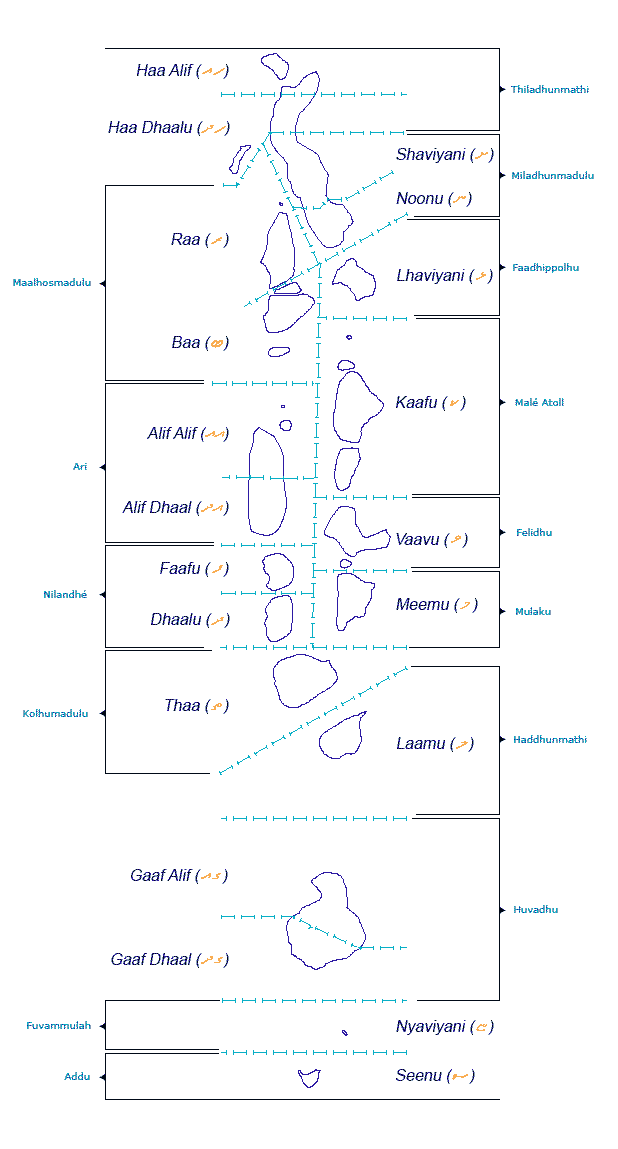
The Maldives has twenty-six natural atolls and few island groups on isolated reefs, all of which have been divided into twenty-one administrative divisions (twenty administrative atolls and Malécity).[77]
Each atoll is administered by an Atoll Chief (Atholhu Veriyaa) appointed by the President. The Ministry of Atoll Administration and its Northern and Southern Regional Offices, Atoll Offices and Island Offices are collectively responsible to the President for Atolls Administration. The administrative head of each island is the IslandChief (Katheeb), appointed by the President. The Island Chief's immediate superior is the Atoll Chief.
The Maldives has 7 provinces each consisting of the following administrative divisions (the capital Malé is its own administrative division):
Mathi-Uthuru Province; consists of Haa Alif Atoll, Haa Dhaalu Atoll and Shaviyani Atoll.
Uthuru Province; consists of Noonu Atoll, Raa Atoll, Baa Atolland Lhaviyani Atoll.
Medhu-Uthuru Province; consists of Kaafu Atoll, Alifu Alifu Atoll, Alifu Dhaalu Atoll and Vaavu Atoll.
Medhu Province; consists of Meemu Atoll, Faafu Atoll andDhaalu Atoll.
Medhu-Dhekunu Province; consists of Thaa Atoll and Laamu Atoll.
Mathi-Dhekunu Province; consists of Gaafu Alifu Atoll and Gaafu Dhaalu Atoll.
Dhekunu Province; consists of Gnaviyani Atoll and Addu City.
In addition to a name, every administrative division is identified by the Maldivian code letters, such as "Haa Alif" for Thiladhunmati Uthuruburi (Thiladhunmathi North); and by a Latin code letter. The first corresponds to the geographical Maldivian name of the atoll; the second is a code adopted for convenience. As there are certain islands in different atolls that have the same name, for administrative purposes this code is quoted before the name of the island, for example: Baa Funadhoo, Kaafu Funadhoo, Gaafu-Alifu Funadhoo. Since most Atolls have very long geographical names it is also used whenever the long name is inconvenient, for example in the atoll website names.[78]
The introduction of code-letter names has been a source of much puzzlement and misunderstandings, especially among foreigners. Many people have come to think that the code-letter of the administrative atoll is its new name and that it has replaced its geographical name. Under such circumstances it is hard to know which is the correct name to use.[78]
Economy[edit]
Main article: Economy of the Maldives
 Graphical depiction of Maldives's product exports in 28 color-coded categories.
In ancient times the Maldives were renowned for cowry shells, coirrope, dried tuna fish (Maldive Fish), ambergris (Maavaharu), andcoco de mer (Tavakkaashi). Local and foreign trading ships used to load these products in Sri Lanka and transport them to other harbours in the Indian Ocean.
Historically Maldives provided enormous quantities of cowry shells,an international currency of the early ages. From the 2nd century AD the islands were known as the 'Money Isles' by the Arabs.[79]Monetaria moneta were used for centuries as a currency in Africa, and huge amounts of Maldivian cowries were introduced into Africa by western nations during the period of slave trade.[80] The cowry is now the symbol of the Maldives Monetary Authority.
The Maldivian government began an economic reform program in 1989, initially by lifting import quotas and opening some exports to the private sector. Subsequently, it has liberalised regulations to allow more foreign investment. Real GDP growth averaged over 7.5% per year for more than a decade. Today, the Maldives' largest industry is tourism, accounting for 28% of GDP and more than 60% of the Maldives' foreign exchange receipts. Fishing is the second leading sector.
The Maldivian economy is to a large degree based on tourism. In late December 2004, the major tsunamileft more than 100 dead, 12,000 displaced, and property damage exceeding $400 million. As a result of the tsunami, the GDP contracted by about 3.6% in 2005. A rebound in tourism, post-tsunami reconstruction, and development of new resorts helped the economy recover quickly and showed an 18% increase on 2006. 2007 estimates show Maldivians enjoy the highest GDP per capita $4,600 (2007 est) among south Asian countries.
Agriculture and manufacturing continue to play a lesser role in the economy, constrained by the limited availability of cultivable land and the shortage of domestic labour. Tourism gave a major boost to the country's fledgling traditional cottage industries such as mat weaving, lacquer work, handicraft, and coir rope making. New industries that have since emerged include printing, production of PVC pipes, brick making, marine engine repairs, bottling of aerated water, and garment production.
Tourism[edit]
Main articles: Tourism in the Maldives and Diving in the Maldives
 Filitheyo island beach with tall palm trees and blue lagoons
Maldives was largely terra incognita for tourists until the early 1970s. Only 185 islands are home to its 300,000 inhabitants. The other islands are used entirely for economic purposes, of which tourism and agriculture are the most dominant. Tourism accounts for 28% of the GDP and more than 60% of the Maldives' foreign exchange receipts. Over 90% of government tax revenue comes from import duties and tourism-related taxes. The development of tourism fostered the overall growth of the country's economy. It created direct and indirect employment and income generation opportunities in other related industries. The first tourist resorts were opened in 1972 with Bandos island resort and Kurumba Village,[81] which transformed the Maldives economy.
According to the Ministry of Tourism, the emergence of tourism in 1972 transformed the economy, moving rapidly from dependence on fisheries to tourism. In just three and a half decades, the industry became the main source of income. Tourism was also the country's biggest foreign currency earner and the single largest contributor to the GDP. As of 2008, 89 resorts in the Maldives offered over 17,000 beds and hosted over 600,000 tourists annually.[82]
The number of resorts increased from 2 to 92 between 1972 and 2007. As of 2007, over 8,380,000 tourists had visited Maldives.[83] Visitors to Maldives do not need to apply for a visa pre-arrival, regardless of their country of origin, provided they have a valid passport, proof of onward travel, and the money to be self-sufficient while in the country.[84]
Most visitors arrive at Malé International Airport, on Hulhulé Island, adjacent to the capital Malé. The airport is served by flights to India, Sri Lanka, Doha, Dubai, Singapore, Istanbul, and major airports in South-East Asia, as well as charters from Europe. Gan Airport, on the southern atoll of Addu, also serves an international flight to Milan several times a week.
Fishing industry[edit]
Main article: Fishing industry in the Maldives
 A mechanised traditional inter island dhoni stripped of its sails
For many centuries the Maldivian economy was entirely dependent on fishing and other marine products. Fishing remains the main occupation of the people and the government gives priority to the fisheries sector.
The mechanisation of the traditional fishing boat called dhoni in 1974 was a major milestone in the development of the fisheries industry. A fish canning plant was installed on Felivaru in 1977, as a joint venture with a Japanese firm. In 1979, a Fisheries Advisory Board was set up with the mandate of advising the government on policy guidelines for the overall development of the fisheries sector. Manpower development programs began in the early 1980s, and fisheries education was incorporated into the school curriculum. Fish aggregating devices and navigational aids were located at various strategic points. Moreover, the opening up of the Exclusive Economic Zone (EEZ) of the Maldives for fisheries has further enhanced the growth of the fisheries sector.
As of 2010, fisheries contributed over 15% of the country's GDP and engaged about 30% of the country's work force. Fisheries were also the second-largest foreign exchange earner after tourism.
Demographics[edit]
Main article: Demographics of the Maldives
 This section needs additional citations for verification. Please helpimprove this article by adding citations to reliable sources. Unsourced material may be challenged and removed. (April 2012)
 Malé, the capital of the Maldives
The Maldivian ethnic identity is a blend of the cultures reflecting the peoples who settled on the islands, reinforced by religion and language. The earliest settlers were probably from southern India and Sri Lanka. They are linguistically and ethnically related to the people in the Indian subcontinent. They are ethnically known as Dhivehis.
Some social stratification exists on the islands. It is not rigid, since rank is based on varied factors, including occupation, wealth, Islamic virtue, and family ties. Instead of a complex caste system, there was merely a distinction between noble (bēfulhu) and common people in the Maldives. Members of the social elite are concentrated in Malé.
A census has been recorded since 1905, which shows that the population of the country remained around 100,000 for the following sixty years. Following independence in 1965, the rate of population growth rose due to improving health.[citation needed] The population doubled by 1978, and the population growth rate peaked at 3.4% in 1985. At the 2006 census, the population had reached 298,968,[85] although the census in 2000 showed that the population growth rate had declined to 1.9%. Life expectancy at birth stood at 46 years in 1978, and later rose to 72. Infant mortality has declined from 12.7% in 1977 to 1.2% today, and adult literacy reached 99%. Combined school enrollment reached the high 90s.
As of April 2008, more than 70,000 foreign employees, along with 33,000 illegal immigrants, comprised more than one third of the Maldivian population. They consisted mainly of people from the neighboring South Asian countries of Sri Lanka, Bangladesh, and Nepal.[citation needed]
Religion[edit]
See also: Islam in the Maldives, Buddhism in the Maldives, and Freedom of religion in the Maldives
 Mosque in Hulhumalé
After the long Buddhist[86] period of Maldivian history, Muslim traders introduced Sunni Islam. Maldivians converted to Islam by the mid-12th century. The islands has had a long history of Sufic orders, as can be seen in the history of the country such as the building of tombs. They were used until as recently as the 1980s for seeking the help of buried Saints. They can be seen today next to some old mosques and are considered today as cultural heritage. Other aspects of tassawuf, such as ritualised dhikr ceremonies called Maulūdu (Mawlid)—the liturgy of which included recitations and certain supplications in a melodical tone—existed until very recent times. These Maulūdu festivals were held in ornate tents specially built for the occasion. At present Sunni Islam is the official religion of the entire population, as adherence to it is required for citizenship.
According to Moroccan traveller Ibn Battuta, the person responsible for this conversion was a Sunni Muslim visitor named Abu al Barakat sailing from Morocco. He is also referred to as Tabrizugefaanu. His venerated tomb now stands on the grounds of the Friday Mosque, or Hukuru miskiy, in Malé. Built in 1656, this is the country's oldest mosque.
Languages[edit]
The official and common language is Dhivehi, an Indo-European language having some similarities withElu, the ancient Sinhalese language. The first known script used to write Dhivehi is Eveyla akuru script which is found in historical recording of kings (raadhavalhi). Later a script called Dhives akuru was used for a long period. The present-day script is called Thaana and is written from right to left. Thaana is said to have been introduced by the reign of Mohamed Thakurufaanu. English is used widely in commerce and increasingly in government schools.
Largest cities[edit]
v
t
eLargest cities or towns of Maldives
by registered population as of July 4, 2012
RankNameDivisionPop.
Malé

Addu City 1 Malé Malé 62,567

Fuvahmulah

Kulhudhuffushi
2 Addu City Addu Atoll 31,999
3 Fuvahmulah Gnaviyani Atoll 11,857
4 Kulhudhuffushi Haa Dhaalu 8,974
5 Thinadhoo Gaafu Dhaalu 7,108
6 Naifaru Lhaviyani 5,133
7 Hinnavaru Lhaviyani 4,676
8 Gan Laamu 4,385
9 Dhuvaafaru Raa 4,368
10 Dhidhdhoo Haa Alifu 3,848
Culture[edit]
Main article: Culture of the Maldives
See also: Music of the Maldives and Maldivian Folklore
This section needs additional citations for verification. Please helpimprove this article by adding citations to reliable sources. Unsourced material may be challenged and removed. (October 2011) Thaana script
 The Islamic Centre, housing the mosque Masjid-al-SultanMohammed Thakurufaanu-al-A'z'am
Maldivian culture is heavily influenced by geographical proximity to Sri Lanka and southern India.
Since the 12th century AD there were also influences from Arabia in the language and culture of the Maldives because of the conversion to Islam and its location as a crossroads in the central Indian Ocean. This was due to the long trading history between the far east and the middle east. Somali travellers discovered the island for gold in the 13th century, before the Portuguese. Their brief stay later ended in a bloody conflict known by the Somalis as "Dagaal Diig Badaaney" in 1424.However, unlike the Sinhalese of Sri Lanka and most of the Arabs, Africans and Europeans whose influence can be seen in borrow-words, material culture, and the diversity of Maldivian phenotype, Maldivians do not have the highly embedded patriarchal codes of honor, purity, corporate marriage, and sedentary private property that are typical of places where agriculture is the key form of subsistence and social relations have been built, historically, around tribute taking. Reflective of this is the fact that the Maldives has had the highest national divorce rate in the world for many decades. This, it is hypothesized, is due to a combination of liberal Islamic rules about divorce and the relatively loose marital bonds that have been identified as common in non and semi-sedentary peoples without a history of fully developed agrarian property and kinship relations.[87]
Transportation[edit]
International travel to the Maldives is available on a number of major airlines. Two Maldives based airlines also operate international flights. Privately owned MEGA Maldives Airlines has Boeing 757 and 767 aircraft and operates frequent services to Beijing, Shanghai, and Hong Kong. Government owned Island Aviation Services (branded as Maldivian) operates to nearly all of Maldives domestic airports with several Dash-8 aircraft and one A320 with international service to Chennai and Thiruvananthapuram, India, and Dhaka, Bangladesh.
In Maldives there are three main ways to move around: by domestic flight, by seaplane or by boat.[88] For several years there were two seaplanes companies operating: TMA, Trans Maldivian Airways, andMaldivian Air Taxi, but these merged in 2013 under the name TMA. The seaplane fleet is entirely made up of DHC-6 "Twin Otters." There is also another airline, flyMe, which operates using ATRs to domestic airports, principally Maamagili and some others. The typical Maldivian boat is called dhoni. Depending on the distance of the destination island to the airport, resorts organise domestic flight plus boat transfers, seaplane flights directly to the resort island jetty, or speedboat trips for their guests. There are also locally run ferries by large dhoni boats. Speedboats and seaplanes tend to be more expensive, while travel by dhoni, although longer, is relatively cheaper.
No comments:
Post a Comment